|
|
|||||||||||||||||
| Point ID: 9413 | Downloads | Plots | Site Data | Code: 15485000 |
|
|
|||||||||||||||||
| Download | |
|---|---|
| Site Descriptor Information | Site Time Series Data |
| Link to all available data | |
|
|
| View: | Statistics | Time Series |
| Units: | mm |
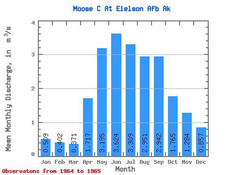
| Statistic | Jan | Feb | Mar | Apr | May | Jun | Jul | Aug | Sep | Oct | Nov | Dec | Annual |
|---|---|---|---|---|---|---|---|---|---|---|---|---|---|
| Mean | 0.51 | 0.40 | 0.37 | 1.72 | 3.19 | 3.62 | 3.31 | 2.95 | 2.94 | 1.77 | 1.28 | 0.86 | |
| Standard Deviation | 0.26 | ||||||||||||
| Min | 0.51 | 0.40 | 0.37 | 1.72 | 3.19 | 3.62 | 3.12 | 2.95 | 2.94 | 1.77 | 1.28 | 0.86 | |
| Max | 0.51 | 0.40 | 0.37 | 1.72 | 3.19 | 3.62 | 3.49 | 2.95 | 2.94 | 1.77 | 1.28 | 0.86 | |
| Coefficient of Variation | 0.08 |
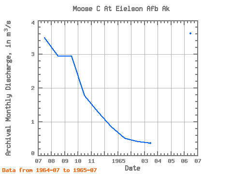
| Year | Jan | Feb | Mar | Apr | May | Jun | Jul | Aug | Sep | Oct | Nov | Dec | Annual | 1964 | 3.49 | 2.95 | 2.94 | 1.77 | 1.28 | 0.86 | 1965 | 0.51 | 0.40 | 0.37 | 1.72 | 3.19 | 3.62 | 3.12 |
|---|
 Return to R-Arctic Net Home Page