|
|
|||||||||||||||||
| Point ID: 9413 | Downloads | Plots | Site Data | Code: 15485000 |
|
|
|||||||||||||||||
| Download | |
|---|---|
| Site Descriptor Information | Site Time Series Data |
| Link to all available data | |
|
|
| View: | Statistics | Time Series |
| Units: | m3/s |
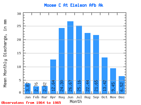
| Statistic | Jan | Feb | Mar | Apr | May | Jun | Jul | Aug | Sep | Oct | Nov | Dec | Annual |
|---|---|---|---|---|---|---|---|---|---|---|---|---|---|
| Mean | 3.87 | 2.79 | 2.82 | 12.64 | 24.30 | 26.67 | 25.16 | 22.44 | 21.65 | 13.42 | 9.45 | 6.51 | |
| Standard Deviation | 1.98 | ||||||||||||
| Min | 3.87 | 2.79 | 2.82 | 12.64 | 24.30 | 26.67 | 23.75 | 22.44 | 21.65 | 13.42 | 9.45 | 6.51 | |
| Max | 3.87 | 2.79 | 2.82 | 12.64 | 24.30 | 26.67 | 26.56 | 22.44 | 21.65 | 13.42 | 9.45 | 6.51 | |
| Coefficient of Variation | 0.08 |
| Year | Jan | Feb | Mar | Apr | May | Jun | Jul | Aug | Sep | Oct | Nov | Dec | Annual | 1964 | 26.56 | 22.44 | 21.65 | 13.42 | 9.45 | 6.51 | 1965 | 3.87 | 2.79 | 2.82 | 12.64 | 24.30 | 26.67 | 23.75 |
|---|
 Return to R-Arctic Net Home Page