|
|
|||||||||||||||||
| Point ID: 9386 | Downloads | Plots | Site Data | Code: 15746900 |
|
|
|||||||||||||||||
| Download | |
|---|---|
| Site Descriptor Information | Site Time Series Data |
| Link to all available data | |
|
|
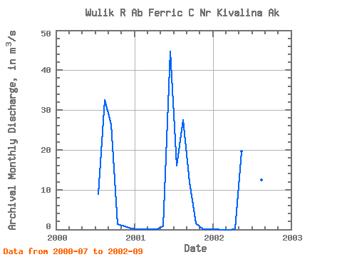
| View: | Statistics | Time Series |
| Units: | mm |
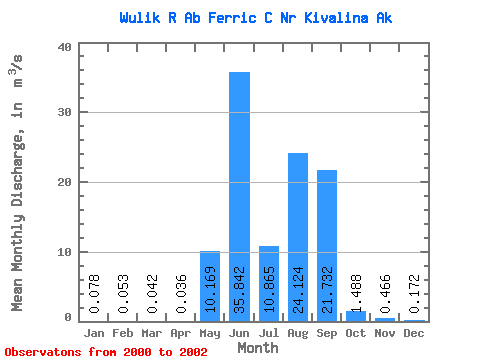
| Statistic | Jan | Feb | Mar | Apr | May | Jun | Jul | Aug | Sep | Oct | Nov | Dec | Annual |
|---|---|---|---|---|---|---|---|---|---|---|---|---|---|
| Mean | 0.08 | 0.05 | 0.04 | 0.04 | 10.17 | 35.84 | 10.87 | 24.12 | 21.73 | 1.49 | 0.47 | 0.17 | 8.58 |
| Standard Deviation | 0.11 | 0.07 | 0.06 | 0.05 | 13.26 | 12.43 | 4.54 | 10.47 | 8.50 | 0.12 | 0.53 | 0.23 | |
| Min | 0.00 | 0.00 | 0.00 | 0.00 | 0.80 | 27.06 | 7.63 | 12.38 | 11.92 | 1.41 | 0.09 | 0.01 | 8.58 |
| Max | 0.15 | 0.11 | 0.08 | 0.07 | 19.54 | 44.63 | 16.05 | 32.49 | 26.81 | 1.57 | 0.84 | 0.33 | 8.58 |
| Coefficient of Variation | 1.37 | 1.41 | 1.41 | 1.36 | 1.30 | 0.35 | 0.42 | 0.43 | 0.39 | 0.08 | 1.13 | 1.32 |
| Year | Jan | Feb | Mar | Apr | May | Jun | Jul | Aug | Sep | Oct | Nov | Dec | Annual | 2000 | 8.91 | 32.49 | 26.46 | 1.41 | 0.84 | 0.33 | 2001 | 0.15 | 0.11 | 0.08 | 0.07 | 0.80 | 44.63 | 16.05 | 27.51 | 11.92 | 1.57 | 0.09 | 0.01 | 8.58 | 2002 | 0.00 | 0.00 | 0.00 | 0.00 | 19.54 | 27.06 | 7.63 | 12.38 | 26.81 |
|---|
 Return to R-Arctic Net Home Page