|
|
|||||||||||||||||
| Point ID: 9386 | Downloads | Plots | Site Data | Code: 15746900 |
|
|
|||||||||||||||||
| Download | |
|---|---|
| Site Descriptor Information | Site Time Series Data |
| Link to all available data | |
|
|
| View: | Statistics | Time Series |
| Units: | m3/s |
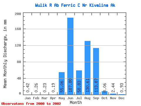
| Statistic | Jan | Feb | Mar | Apr | May | Jun | Jul | Aug | Sep | Oct | Nov | Dec | Annual |
|---|---|---|---|---|---|---|---|---|---|---|---|---|---|
| Mean | 0.42 | 0.26 | 0.23 | 0.19 | 55.05 | 187.80 | 58.81 | 130.59 | 113.86 | 8.06 | 2.44 | 0.93 | 547.52 |
| Standard Deviation | 0.58 | 0.37 | 0.32 | 0.26 | 71.75 | 65.11 | 24.55 | 56.69 | 44.54 | 0.62 | 2.76 | 1.23 | |
| Min | 0.01 | 0.00 | 0.00 | 0.01 | 4.31 | 141.76 | 41.30 | 67.01 | 62.44 | 7.62 | 0.49 | 0.06 | 547.52 |
| Max | 0.83 | 0.52 | 0.45 | 0.37 | 105.79 | 233.83 | 86.88 | 175.86 | 140.49 | 8.50 | 4.40 | 1.80 | 547.52 |
| Coefficient of Variation | 1.37 | 1.41 | 1.41 | 1.36 | 1.30 | 0.35 | 0.42 | 0.43 | 0.39 | 0.08 | 1.13 | 1.32 |
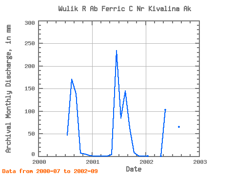
| Year | Jan | Feb | Mar | Apr | May | Jun | Jul | Aug | Sep | Oct | Nov | Dec | Annual | 2000 | 48.26 | 175.86 | 138.65 | 7.62 | 4.40 | 1.80 | 2001 | 0.83 | 0.52 | 0.45 | 0.37 | 4.31 | 233.83 | 86.88 | 148.90 | 62.44 | 8.50 | 0.49 | 0.06 | 547.52 | 2002 | 0.01 | 0.00 | 0.00 | 0.01 | 105.79 | 141.76 | 41.30 | 67.01 | 140.49 |
|---|
 Return to R-Arctic Net Home Page