|
|
|||||||||||||||||
| Point ID: 9384 | Downloads | Plots | Site Data | Code: 15743000 |
|
|
|||||||||||||||||
| Download | |
|---|---|
| Site Descriptor Information | Site Time Series Data |
| Link to all available data | |
|
|
| View: | Statistics | Time Series |
| Units: | mm |
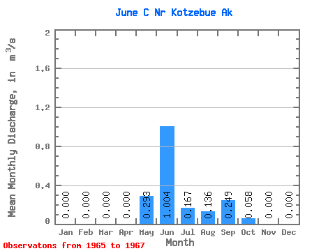
| Statistic | Jan | Feb | Mar | Apr | May | Jun | Jul | Aug | Sep | Oct | Nov | Dec | Annual |
|---|---|---|---|---|---|---|---|---|---|---|---|---|---|
| Mean | 0.00 | 0.00 | 0.00 | 0.00 | 0.29 | 1.00 | 0.17 | 0.14 | 0.25 | 0.06 | 0.00 | 0.00 | 0.13 |
| Standard Deviation | 0.00 | 0.00 | 0.00 | 0.00 | 0.41 | 0.62 | 0.11 | 0.10 | 0.35 | 0.06 | 0.00 | 0.00 | |
| Min | 0.00 | 0.00 | 0.00 | 0.00 | 0.00 | 0.31 | 0.04 | 0.04 | 0.02 | 0.02 | 0.00 | 0.00 | 0.13 |
| Max | 0.00 | 0.00 | 0.00 | 0.00 | 0.58 | 1.51 | 0.25 | 0.24 | 0.65 | 0.10 | 0.00 | 0.00 | 0.13 |
| Coefficient of Variation | 1.41 | 0.62 | 0.65 | 0.76 | 1.39 | 0.96 |
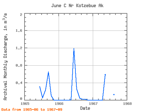
| Year | Jan | Feb | Mar | Apr | May | Jun | Jul | Aug | Sep | Oct | Nov | Dec | Annual | 1965 | 0.31 | 0.04 | 0.24 | 0.65 | 0.10 | 0.00 | 0.00 | 1966 | 0.00 | 0.00 | 0.00 | 0.00 | 0.00 | 1.19 | 0.25 | 0.04 | 0.02 | 0.02 | 0.00 | 0.00 | 0.13 | 1967 | 0.00 | 0.00 | 0.00 | 0.00 | 0.58 | 1.51 | 0.21 | 0.13 | 0.08 |
|---|
 Return to R-Arctic Net Home Page