|
|
|||||||||||||||||
| Point ID: 9384 | Downloads | Plots | Site Data | Code: 15743000 |
|
|
|||||||||||||||||
| Download | |
|---|---|
| Site Descriptor Information | Site Time Series Data |
| Link to all available data | |
|
|
| View: | Statistics | Time Series |
| Units: | m3/s |
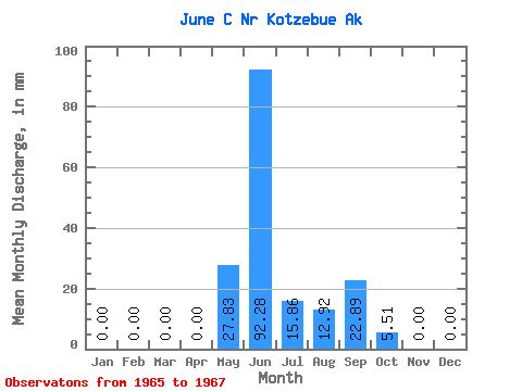
| Statistic | Jan | Feb | Mar | Apr | May | Jun | Jul | Aug | Sep | Oct | Nov | Dec | Annual |
|---|---|---|---|---|---|---|---|---|---|---|---|---|---|
| Mean | 0.00 | 0.00 | 0.00 | 0.00 | 27.79 | 92.33 | 15.89 | 12.87 | 22.87 | 5.48 | 0.00 | 0.00 | 141.48 |
| Standard Deviation | 0.00 | 0.00 | 0.00 | 0.00 | 39.08 | 57.24 | 10.38 | 9.72 | 31.88 | 5.27 | 0.00 | 0.00 | |
| Min | 0.00 | 0.00 | 0.00 | 0.00 | 0.16 | 28.51 | 4.18 | 3.64 | 1.59 | 1.75 | 0.00 | 0.00 | 141.48 |
| Max | 0.00 | 0.00 | 0.00 | 0.00 | 55.42 | 139.15 | 23.93 | 23.01 | 59.52 | 9.21 | 0.00 | 0.00 | 141.48 |
| Coefficient of Variation | 1.41 | 0.62 | 0.65 | 0.76 | 1.39 | 0.96 |
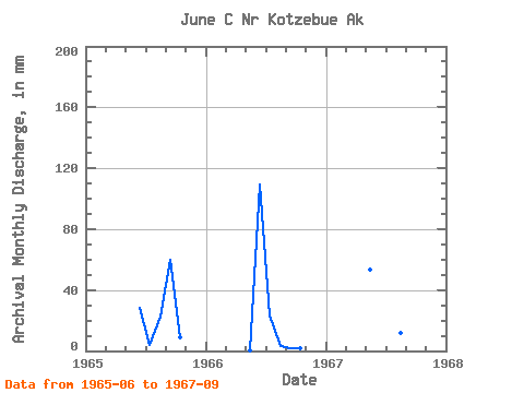
| Year | Jan | Feb | Mar | Apr | May | Jun | Jul | Aug | Sep | Oct | Nov | Dec | Annual | 1965 | 28.51 | 4.18 | 23.01 | 59.52 | 9.21 | 0.00 | 0.00 | 1966 | 0.00 | 0.00 | 0.00 | 0.00 | 0.16 | 109.32 | 23.93 | 3.64 | 1.59 | 1.75 | 0.00 | 0.00 | 141.48 | 1967 | 0.00 | 0.00 | 0.00 | 0.00 | 55.42 | 139.15 | 19.56 | 11.97 | 7.49 |
|---|
 Return to R-Arctic Net Home Page