|
|
|||||||||||||||||
| Point ID: 9368 | Downloads | Plots | Site Data | Code: 15302500 |
|
|
|||||||||||||||||
| Download | |
|---|---|
| Site Descriptor Information | Site Time Series Data |
| Link to all available data | |
| View: | Time Series | All |
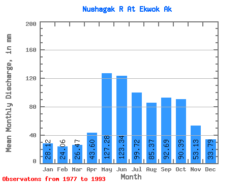
| Units: | m3/s |
| Statistic | Jan | Feb | Mar | Apr | May | Jun | Jul | Aug | Sep | Oct | Nov | Dec | Annual |
|---|---|---|---|---|---|---|---|---|---|---|---|---|---|
| Mean | 28.11 | 24.26 | 26.47 | 43.60 | 127.26 | 123.34 | 99.70 | 85.36 | 92.69 | 90.38 | 53.13 | 33.78 | 820.77 |
| Standard Deviation | 6.15 | 5.50 | 6.09 | 22.27 | 42.85 | 30.04 | 27.26 | 20.11 | 35.25 | 30.29 | 20.00 | 9.64 | 135.46 |
| Min | 19.10 | 16.64 | 17.53 | 16.50 | 62.10 | 69.89 | 64.73 | 52.37 | 37.89 | 40.61 | 26.64 | 19.25 | 545.60 |
| Max | 39.22 | 35.21 | 36.53 | 90.00 | 207.21 | 169.28 | 156.68 | 116.63 | 171.44 | 145.74 | 104.10 | 48.13 | 1046.88 |
| Coefficient of Variation | 0.22 | 0.23 | 0.23 | 0.51 | 0.34 | 0.24 | 0.27 | 0.24 | 0.38 | 0.34 | 0.38 | 0.28 | 0.17 |
 Return to R-Arctic Net Home Page