|
|
|||||||||||||||||
| Point ID: 9368 | Downloads | Plots | Site Data | Code: 15302500 |
|
|
|||||||||||||||||
| Download | |
|---|---|
| Site Descriptor Information | Site Time Series Data |
| Link to all available data | |
| View: | Time Series | All |
| Units: | mm |
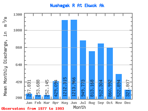
| Statistic | Jan | Feb | Mar | Apr | May | Jun | Jul | Aug | Sep | Oct | Nov | Dec | Annual |
|---|---|---|---|---|---|---|---|---|---|---|---|---|---|
| Mean | 267.83 | 253.69 | 252.15 | 429.09 | 1212.32 | 1213.97 | 949.77 | 813.17 | 912.30 | 860.99 | 522.89 | 321.81 | 663.47 |
| Standard Deviation | 58.56 | 57.53 | 57.99 | 219.15 | 408.17 | 295.63 | 259.73 | 191.59 | 346.92 | 288.53 | 196.80 | 91.86 | 109.50 |
| Min | 181.96 | 173.95 | 166.98 | 162.35 | 591.55 | 687.91 | 616.67 | 498.93 | 372.93 | 386.85 | 262.21 | 183.33 | 441.03 |
| Max | 373.60 | 368.12 | 348.02 | 885.85 | 1973.96 | 1666.07 | 1492.57 | 1111.03 | 1687.40 | 1388.35 | 1024.60 | 458.55 | 846.24 |
| Coefficient of Variation | 0.22 | 0.23 | 0.23 | 0.51 | 0.34 | 0.24 | 0.27 | 0.24 | 0.38 | 0.34 | 0.38 | 0.28 | 0.17 |
 Return to R-Arctic Net Home Page