|
|
|||||||||||||||||
| Point ID: 9354 | Downloads | Plots | Site Data | Code: 15474000 |
|
|
|||||||||||||||||
| Download | |
|---|---|
| Site Descriptor Information | Site Time Series Data |
| Link to all available data | |
|
|
| View: | Statistics | Time Series |
| Units: | mm |
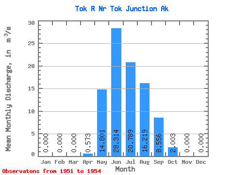
| Statistic | Jan | Feb | Mar | Apr | May | Jun | Jul | Aug | Sep | Oct | Nov | Dec | Annual |
|---|---|---|---|---|---|---|---|---|---|---|---|---|---|
| Mean | 0.00 | 0.00 | 0.00 | 0.57 | 14.80 | 28.31 | 20.79 | 16.22 | 8.56 | 2.00 | 0.00 | 0.00 | 8.84 |
| Standard Deviation | 0.00 | 0.00 | 0.00 | 0.80 | 8.06 | 23.24 | 11.81 | 6.85 | 4.62 | 1.91 | 0.00 | 0.00 | 3.56 |
| Min | 0.00 | 0.00 | 0.00 | 0.00 | 5.70 | 11.61 | 11.97 | 10.48 | 4.67 | 0.40 | 0.00 | 0.00 | 6.33 |
| Max | 0.00 | 0.00 | 0.00 | 1.48 | 21.04 | 54.85 | 34.21 | 23.80 | 13.66 | 4.11 | 0.00 | 0.00 | 11.36 |
| Coefficient of Variation | 1.39 | 0.55 | 0.82 | 0.57 | 0.42 | 0.54 | 0.95 | 0.40 |
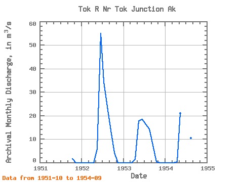
| Year | Jan | Feb | Mar | Apr | May | Jun | Jul | Aug | Sep | Oct | Nov | Dec | Annual | 1951 | 1.51 | 0.00 | 0.00 | 1952 | 0.00 | 0.00 | 0.00 | 0.00 | 5.70 | 54.85 | 34.21 | 23.80 | 13.66 | 4.11 | 0.00 | 0.00 | 11.36 | 1953 | 0.00 | 0.00 | 0.00 | 1.48 | 17.67 | 18.48 | 16.18 | 14.37 | 7.33 | 0.40 | 0.00 | 0.00 | 6.33 | 1954 | 0.00 | 0.00 | 0.00 | 0.24 | 21.04 | 11.61 | 11.97 | 10.48 | 4.67 |
|---|
 Return to R-Arctic Net Home Page