|
|
|||||||||||||||||
| Point ID: 9354 | Downloads | Plots | Site Data | Code: 15474000 |
|
|
|||||||||||||||||
| Download | |
|---|---|
| Site Descriptor Information | Site Time Series Data |
| Link to all available data | |
|
|
| View: | Statistics | Time Series |
| Units: | m3/s |
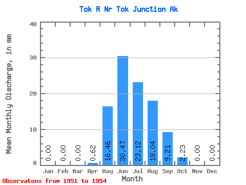
| Statistic | Jan | Feb | Mar | Apr | May | Jun | Jul | Aug | Sep | Oct | Nov | Dec | Annual |
|---|---|---|---|---|---|---|---|---|---|---|---|---|---|
| Mean | 0.00 | 0.00 | 0.00 | 0.62 | 16.46 | 30.47 | 23.11 | 18.03 | 9.21 | 2.23 | 0.00 | 0.00 | 115.87 |
| Standard Deviation | 0.00 | 0.00 | 0.00 | 0.86 | 8.96 | 25.01 | 13.13 | 7.62 | 4.97 | 2.12 | 0.00 | 0.00 | 46.65 |
| Min | 0.00 | 0.00 | 0.00 | 0.00 | 6.33 | 12.49 | 13.31 | 11.65 | 5.03 | 0.44 | 0.00 | 0.00 | 82.88 |
| Max | 0.00 | 0.00 | 0.00 | 1.59 | 23.39 | 59.03 | 38.03 | 26.47 | 14.70 | 4.56 | 0.00 | 0.00 | 148.86 |
| Coefficient of Variation | 1.39 | 0.55 | 0.82 | 0.57 | 0.42 | 0.54 | 0.95 | 0.40 |
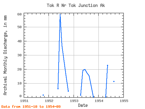
| Year | Jan | Feb | Mar | Apr | May | Jun | Jul | Aug | Sep | Oct | Nov | Dec | Annual | 1951 | 1.68 | 0.00 | 0.00 | 1952 | 0.00 | 0.00 | 0.00 | 0.00 | 6.33 | 59.03 | 38.03 | 26.47 | 14.70 | 4.56 | 0.00 | 0.00 | 148.86 | 1953 | 0.00 | 0.00 | 0.00 | 1.59 | 19.64 | 19.88 | 17.99 | 15.98 | 7.89 | 0.44 | 0.00 | 0.00 | 82.88 | 1954 | 0.00 | 0.00 | 0.00 | 0.25 | 23.39 | 12.49 | 13.31 | 11.65 | 5.03 |
|---|
 Return to R-Arctic Net Home Page