|
|
|||||||||||||||||
| Point ID: 9318 | Downloads | Plots | Site Data | Code: 15056400 |
|
|
|||||||||||||||||
| Download | |
|---|---|
| Site Descriptor Information | Site Time Series Data |
| Link to all available data | |
|
|
| View: | Statistics | Time Series |
| Units: | mm |
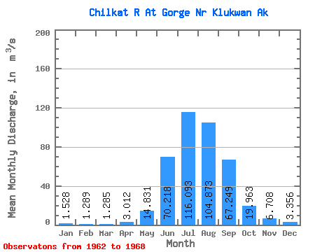
| Statistic | Jan | Feb | Mar | Apr | May | Jun | Jul | Aug | Sep | Oct | Nov | Dec | Annual |
|---|---|---|---|---|---|---|---|---|---|---|---|---|---|
| Mean | 1.53 | 1.29 | 1.28 | 3.01 | 14.83 | 70.22 | 116.09 | 104.87 | 67.25 | 19.96 | 6.71 | 3.36 | 33.24 |
| Standard Deviation | 0.58 | 0.38 | 0.67 | 1.15 | 7.20 | 31.92 | 17.00 | 21.15 | 36.34 | 3.64 | 3.93 | 1.42 | 5.75 |
| Min | 0.78 | 0.76 | 0.51 | 1.43 | 7.62 | 27.24 | 98.10 | 73.47 | 33.27 | 14.68 | 3.83 | 1.19 | 28.79 |
| Max | 2.49 | 1.86 | 2.40 | 4.38 | 27.39 | 112.66 | 139.16 | 139.38 | 134.64 | 24.61 | 13.97 | 5.55 | 43.07 |
| Coefficient of Variation | 0.38 | 0.30 | 0.52 | 0.38 | 0.48 | 0.46 | 0.15 | 0.20 | 0.54 | 0.18 | 0.58 | 0.42 | 0.17 |
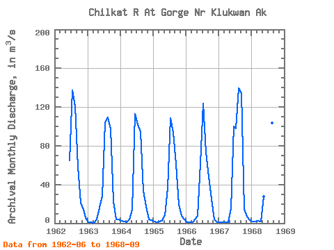
| Year | Jan | Feb | Mar | Apr | May | Jun | Jul | Aug | Sep | Oct | Nov | Dec | Annual | 1962 | 64.58 | 136.94 | 120.52 | 58.08 | 21.41 | 13.97 | 5.55 | 1963 | 1.33 | 0.76 | 0.51 | 3.92 | 16.20 | 27.24 | 104.02 | 109.20 | 97.16 | 22.72 | 3.87 | 3.59 | 32.54 | 1964 | 2.49 | 1.50 | 0.95 | 3.68 | 13.96 | 112.66 | 102.51 | 94.05 | 33.27 | 17.64 | 3.83 | 2.88 | 32.45 | 1965 | 1.55 | 1.38 | 1.58 | 2.52 | 8.06 | 36.42 | 108.42 | 93.74 | 61.48 | 18.73 | 7.79 | 3.81 | 28.79 | 1966 | 1.25 | 1.05 | 1.40 | 4.38 | 7.62 | 62.11 | 123.51 | 73.47 | 47.77 | 24.61 | 4.08 | 1.19 | 29.37 | 1967 | 0.78 | 1.17 | 0.88 | 1.43 | 15.77 | 100.19 | 98.10 | 139.38 | 134.64 | 14.68 | 6.70 | 3.11 | 43.07 | 1968 | 1.78 | 1.86 | 2.40 | 2.14 | 27.39 | 88.33 | 139.16 | 103.75 | 38.35 |
|---|
 Return to R-Arctic Net Home Page