|
|
|||||||||||||||||
| Point ID: 9318 | Downloads | Plots | Site Data | Code: 15056400 |
|
|
|||||||||||||||||
| Download | |
|---|---|
| Site Descriptor Information | Site Time Series Data |
| Link to all available data | |
|
|
| View: | Statistics | Time Series |
| Units: | m3/s |
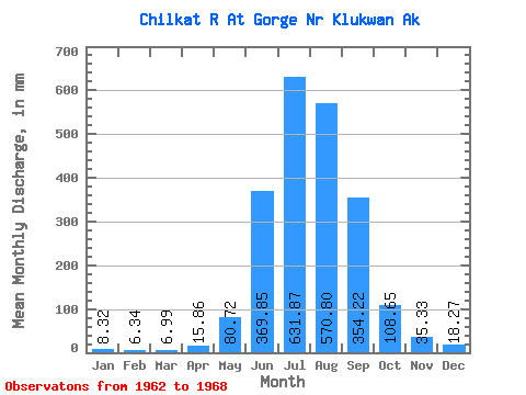
| Statistic | Jan | Feb | Mar | Apr | May | Jun | Jul | Aug | Sep | Oct | Nov | Dec | Annual |
|---|---|---|---|---|---|---|---|---|---|---|---|---|---|
| Mean | 8.32 | 6.39 | 6.99 | 15.87 | 80.71 | 369.86 | 631.77 | 570.72 | 354.22 | 108.64 | 35.33 | 18.27 | 2132.08 |
| Standard Deviation | 3.14 | 1.90 | 3.64 | 6.06 | 39.16 | 168.15 | 92.51 | 115.08 | 191.40 | 19.80 | 20.68 | 7.72 | 369.11 |
| Min | 4.23 | 3.79 | 2.76 | 7.55 | 41.49 | 143.49 | 533.88 | 399.81 | 175.24 | 79.88 | 20.18 | 6.48 | 1846.38 |
| Max | 13.55 | 9.25 | 13.07 | 23.06 | 149.03 | 593.42 | 757.28 | 758.52 | 709.18 | 133.94 | 73.57 | 30.22 | 2762.13 |
| Coefficient of Variation | 0.38 | 0.30 | 0.52 | 0.38 | 0.48 | 0.46 | 0.15 | 0.20 | 0.54 | 0.18 | 0.58 | 0.42 | 0.17 |
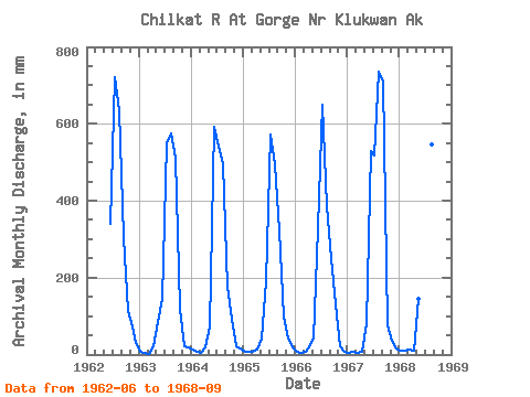
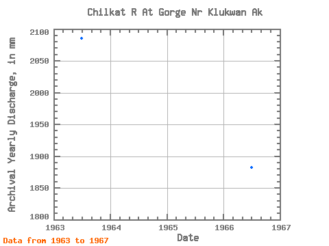
| Year | Jan | Feb | Mar | Apr | May | Jun | Jul | Aug | Sep | Oct | Nov | Dec | Annual | 1962 | 340.18 | 745.20 | 655.87 | 305.94 | 116.48 | 73.57 | 30.22 | 1963 | 7.25 | 3.79 | 2.76 | 20.63 | 88.14 | 143.49 | 566.09 | 594.28 | 511.74 | 123.66 | 20.39 | 19.54 | 2087.14 | 1964 | 13.55 | 7.44 | 5.16 | 19.39 | 75.96 | 593.42 | 557.84 | 511.81 | 175.24 | 95.97 | 20.18 | 15.69 | 2081.21 | 1965 | 8.42 | 6.86 | 8.62 | 13.29 | 43.85 | 191.82 | 590.00 | 510.12 | 323.81 | 101.91 | 41.06 | 20.73 | 1846.38 | 1966 | 6.79 | 5.23 | 7.59 | 23.06 | 41.49 | 327.13 | 672.12 | 399.81 | 251.59 | 133.94 | 21.51 | 6.48 | 1883.56 | 1967 | 4.23 | 5.78 | 4.76 | 7.55 | 85.80 | 527.70 | 533.88 | 758.52 | 709.18 | 79.88 | 35.30 | 16.93 | 2762.13 | 1968 | 9.67 | 9.25 | 13.07 | 11.27 | 149.03 | 465.25 | 757.28 | 564.60 | 202.01 |
|---|
 Return to R-Arctic Net Home Page