|
|
|||||||||||||||||
| Point ID: 9309 | Downloads | Plots | Site Data | Code: 15057590 |
|
|
|||||||||||||||||
| Download | |
|---|---|
| Site Descriptor Information | Site Time Series Data |
| Link to all available data | |
|
|
| View: | Statistics | Time Series |
| Units: | mm |
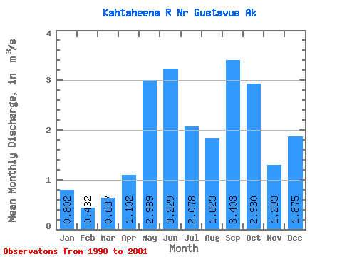
| Statistic | Jan | Feb | Mar | Apr | May | Jun | Jul | Aug | Sep | Oct | Nov | Dec | Annual |
|---|---|---|---|---|---|---|---|---|---|---|---|---|---|
| Mean | 0.80 | 0.43 | 0.64 | 1.10 | 2.99 | 3.23 | 2.08 | 1.82 | 3.40 | 2.93 | 1.29 | 1.88 | 1.96 |
| Standard Deviation | 0.43 | 0.27 | 0.09 | 0.83 | 0.48 | 0.04 | 0.37 | 0.06 | 0.61 | 0.72 | 0.57 | 1.66 | 0.33 |
| Min | 0.54 | 0.22 | 0.54 | 0.24 | 2.65 | 3.20 | 1.81 | 1.78 | 2.97 | 2.22 | 0.65 | 0.71 | 1.73 |
| Max | 1.29 | 0.73 | 0.71 | 1.91 | 3.33 | 3.26 | 2.34 | 1.87 | 3.83 | 3.66 | 1.75 | 3.77 | 2.19 |
| Coefficient of Variation | 0.53 | 0.62 | 0.13 | 0.76 | 0.16 | 0.01 | 0.18 | 0.04 | 0.18 | 0.25 | 0.44 | 0.89 | 0.17 |
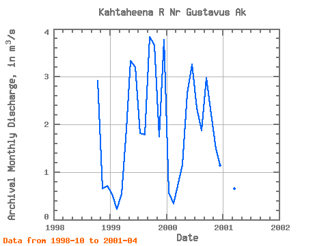
| Year | Jan | Feb | Mar | Apr | May | Jun | Jul | Aug | Sep | Oct | Nov | Dec | Annual | 1998 | 2.91 | 0.65 | 0.71 | 1999 | 0.54 | 0.22 | 0.54 | 1.91 | 3.33 | 3.20 | 1.81 | 1.78 | 3.83 | 3.66 | 1.75 | 3.77 | 2.19 | 2000 | 0.57 | 0.34 | 0.71 | 1.16 | 2.65 | 3.26 | 2.34 | 1.87 | 2.97 | 2.22 | 1.48 | 1.14 | 1.73 | 2001 | 1.29 | 0.73 | 0.66 | 0.24 |
|---|
 Return to R-Arctic Net Home Page