|
|
|||||||||||||||||
| Point ID: 9309 | Downloads | Plots | Site Data | Code: 15057590 |
|
|
|||||||||||||||||
| Download | |
|---|---|
| Site Descriptor Information | Site Time Series Data |
| Link to all available data | |
|
|
| View: | Statistics | Time Series |
| Units: | m3/s |
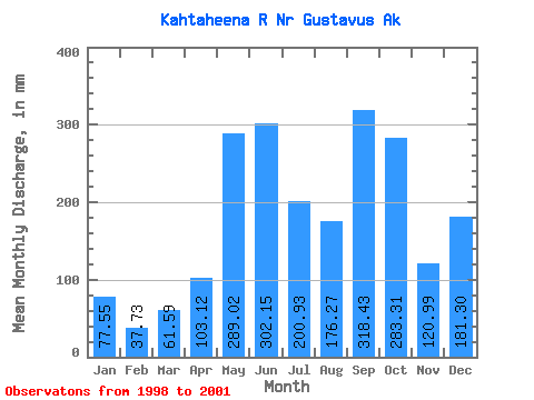
| Statistic | Jan | Feb | Mar | Apr | May | Jun | Jul | Aug | Sep | Oct | Nov | Dec | Annual |
|---|---|---|---|---|---|---|---|---|---|---|---|---|---|
| Mean | 77.49 | 38.06 | 61.62 | 103.11 | 289.00 | 302.15 | 200.90 | 176.23 | 318.45 | 283.28 | 120.98 | 181.23 | 2233.65 |
| Standard Deviation | 41.37 | 23.73 | 8.25 | 77.95 | 46.52 | 3.88 | 36.09 | 6.18 | 56.90 | 69.56 | 53.34 | 160.30 | 377.66 |
| Min | 52.01 | 19.19 | 52.63 | 22.61 | 256.11 | 299.41 | 175.38 | 171.86 | 278.22 | 214.60 | 61.12 | 68.88 | 1966.61 |
| Max | 125.22 | 64.71 | 68.84 | 178.25 | 321.90 | 304.90 | 226.42 | 180.60 | 358.69 | 353.69 | 163.49 | 364.81 | 2500.70 |
| Coefficient of Variation | 0.53 | 0.62 | 0.13 | 0.76 | 0.16 | 0.01 | 0.18 | 0.04 | 0.18 | 0.25 | 0.44 | 0.89 | 0.17 |
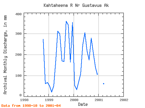
| Year | Jan | Feb | Mar | Apr | May | Jun | Jul | Aug | Sep | Oct | Nov | Dec | Annual | 1998 | 281.55 | 61.12 | 68.88 | 1999 | 52.01 | 19.19 | 52.63 | 178.25 | 321.90 | 299.41 | 175.38 | 171.86 | 358.69 | 353.69 | 163.49 | 364.81 | 2500.70 | 2000 | 55.24 | 30.29 | 68.84 | 108.46 | 256.11 | 304.90 | 226.42 | 180.60 | 278.22 | 214.60 | 138.31 | 110.02 | 1966.61 | 2001 | 125.22 | 64.71 | 63.40 | 22.61 |
|---|
 Return to R-Arctic Net Home Page