|
|
|||||||||||||||||
| Point ID: 9302 | Downloads | Plots | Site Data | Code: 15085300 |
|
|
|||||||||||||||||
| Download | |
|---|---|
| Site Descriptor Information | Site Time Series Data |
| Link to all available data | |
|
|
| View: | Statistics | Time Series |
| Units: | mm |
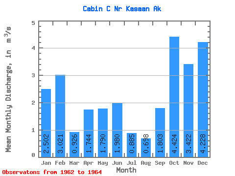
| Statistic | Jan | Feb | Mar | Apr | May | Jun | Jul | Aug | Sep | Oct | Nov | Dec | Annual |
|---|---|---|---|---|---|---|---|---|---|---|---|---|---|
| Mean | 2.50 | 3.02 | 0.93 | 1.74 | 1.79 | 1.98 | 0.89 | 0.70 | 1.80 | 4.42 | 3.42 | 4.23 | 2.18 |
| Standard Deviation | 0.45 | 0.20 | 0.08 | 0.04 | 0.92 | 0.94 | 0.45 | 0.43 | 0.48 | 2.08 | 1.15 | 0.56 | |
| Min | 2.18 | 2.88 | 0.87 | 1.72 | 1.14 | 1.09 | 0.41 | 0.25 | 1.35 | 2.96 | 2.61 | 3.83 | 2.18 |
| Max | 2.82 | 3.16 | 0.98 | 1.77 | 2.44 | 2.96 | 1.32 | 1.10 | 2.31 | 5.89 | 4.23 | 4.62 | 2.18 |
| Coefficient of Variation | 0.18 | 0.07 | 0.09 | 0.02 | 0.51 | 0.47 | 0.51 | 0.62 | 0.27 | 0.47 | 0.34 | 0.13 |
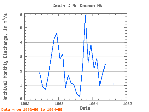
| Year | Jan | Feb | Mar | Apr | May | Jun | Jul | Aug | Sep | Oct | Nov | Dec | Annual | 1962 | 1.89 | 0.92 | 0.74 | 1.75 | 2.96 | 4.23 | 4.62 | 1963 | 2.82 | 3.16 | 0.87 | 1.72 | 1.14 | 1.09 | 0.41 | 0.25 | 2.31 | 5.89 | 2.61 | 3.83 | 2.18 | 1964 | 2.18 | 2.88 | 0.98 | 1.77 | 2.44 | 2.96 | 1.32 | 1.10 | 1.35 |
|---|
 Return to R-Arctic Net Home Page