|
|
|||||||||||||||||
| Point ID: 9302 | Downloads | Plots | Site Data | Code: 15085300 |
|
|
|||||||||||||||||
| Download | |
|---|---|
| Site Descriptor Information | Site Time Series Data |
| Link to all available data | |
|

|
| View: | Statistics | Time Series |
| Units: | m3/s |
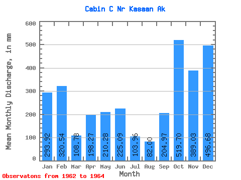
| Statistic | Jan | Feb | Mar | Apr | May | Jun | Jul | Aug | Sep | Oct | Nov | Dec | Annual |
|---|---|---|---|---|---|---|---|---|---|---|---|---|---|
| Mean | 293.93 | 323.30 | 108.80 | 198.25 | 210.23 | 225.10 | 103.91 | 81.94 | 204.93 | 519.61 | 389.05 | 496.59 | 3012.06 |
| Standard Deviation | 53.03 | 21.70 | 9.25 | 4.31 | 107.95 | 106.72 | 53.17 | 50.50 | 55.09 | 243.69 | 130.30 | 65.47 | |
| Min | 256.43 | 307.95 | 102.26 | 195.20 | 133.90 | 123.95 | 48.63 | 28.95 | 153.02 | 347.29 | 296.91 | 450.29 | 3012.06 |
| Max | 331.43 | 338.64 | 115.34 | 201.30 | 286.57 | 336.62 | 154.69 | 129.51 | 262.72 | 691.92 | 481.18 | 542.88 | 3012.06 |
| Coefficient of Variation | 0.18 | 0.07 | 0.09 | 0.02 | 0.51 | 0.47 | 0.51 | 0.62 | 0.27 | 0.47 | 0.34 | 0.13 |
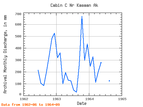
| Year | Jan | Feb | Mar | Apr | May | Jun | Jul | Aug | Sep | Oct | Nov | Dec | Annual | 1962 | 214.72 | 108.41 | 87.35 | 199.03 | 347.29 | 481.18 | 542.88 | 1963 | 331.43 | 338.64 | 102.26 | 195.20 | 133.90 | 123.95 | 48.63 | 28.95 | 262.72 | 691.92 | 296.91 | 450.29 | 3012.06 | 1964 | 256.43 | 307.95 | 115.34 | 201.30 | 286.57 | 336.62 | 154.69 | 129.51 | 153.02 |
|---|
 Return to R-Arctic Net Home Page