|
|
|||||||||||||||||
| Point ID: 9300 | Downloads | Plots | Site Data | Code: 15085000 |
|
|
|||||||||||||||||
| Download | |
|---|---|
| Site Descriptor Information | Site Time Series Data |
| Link to all available data | |
|
|
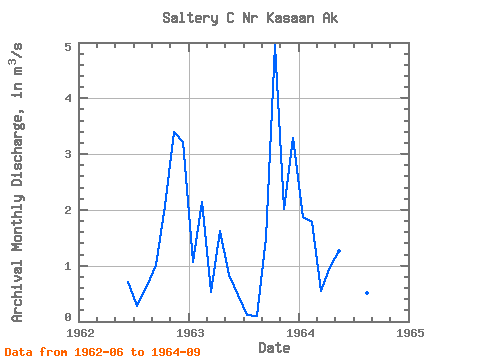
| View: | Statistics | Time Series |
| Units: | mm |
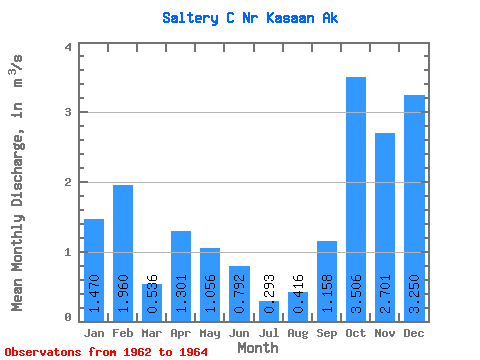
| Statistic | Jan | Feb | Mar | Apr | May | Jun | Jul | Aug | Sep | Oct | Nov | Dec | Annual |
|---|---|---|---|---|---|---|---|---|---|---|---|---|---|
| Mean | 1.47 | 1.96 | 0.54 | 1.30 | 1.06 | 0.79 | 0.29 | 0.42 | 1.16 | 3.51 | 2.70 | 3.25 | 1.55 |
| Standard Deviation | 0.58 | 0.25 | 0.00 | 0.46 | 0.30 | 0.36 | 0.19 | 0.29 | 0.29 | 2.04 | 0.98 | 0.05 | |
| Min | 1.06 | 1.78 | 0.53 | 0.97 | 0.84 | 0.47 | 0.11 | 0.09 | 0.96 | 2.06 | 2.01 | 3.21 | 1.55 |
| Max | 1.88 | 2.14 | 0.54 | 1.63 | 1.27 | 1.19 | 0.49 | 0.64 | 1.49 | 4.95 | 3.40 | 3.29 | 1.55 |
| Coefficient of Variation | 0.40 | 0.13 | 0.01 | 0.36 | 0.29 | 0.46 | 0.65 | 0.69 | 0.25 | 0.58 | 0.36 | 0.02 |
| Year | Jan | Feb | Mar | Apr | May | Jun | Jul | Aug | Sep | Oct | Nov | Dec | Annual | 1962 | 0.71 | 0.28 | 0.64 | 1.01 | 2.06 | 3.40 | 3.21 | 1963 | 1.06 | 2.14 | 0.53 | 1.63 | 0.84 | 0.47 | 0.11 | 0.09 | 1.49 | 4.95 | 2.01 | 3.29 | 1.55 | 1964 | 1.88 | 1.78 | 0.54 | 0.97 | 1.27 | 1.19 | 0.49 | 0.51 | 0.96 |
|---|
 Return to R-Arctic Net Home Page