|
|
|||||||||||||||||
| Point ID: 9300 | Downloads | Plots | Site Data | Code: 15085000 |
|
|
|||||||||||||||||
| Download | |
|---|---|
| Site Descriptor Information | Site Time Series Data |
| Link to all available data | |
|
|
| View: | Statistics | Time Series |
| Units: | m3/s |
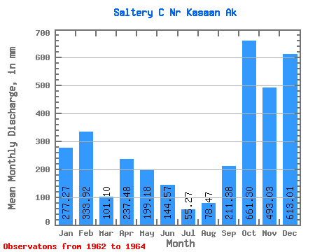
| Statistic | Jan | Feb | Mar | Apr | May | Jun | Jul | Aug | Sep | Oct | Nov | Dec | Annual |
|---|---|---|---|---|---|---|---|---|---|---|---|---|---|
| Mean | 277.25 | 336.75 | 101.16 | 237.54 | 199.23 | 144.48 | 55.32 | 78.46 | 211.31 | 661.25 | 493.12 | 613.00 | 3447.72 |
| Standard Deviation | 109.54 | 42.74 | 0.60 | 84.45 | 57.36 | 66.65 | 35.76 | 54.17 | 53.27 | 384.80 | 179.06 | 9.95 | |
| Min | 199.79 | 306.53 | 100.74 | 177.83 | 158.67 | 86.10 | 21.31 | 17.62 | 176.09 | 389.15 | 366.50 | 605.96 | 3447.72 |
| Max | 354.71 | 366.97 | 101.59 | 297.26 | 239.78 | 217.09 | 92.60 | 121.48 | 272.60 | 933.35 | 619.73 | 620.03 | 3447.72 |
| Coefficient of Variation | 0.40 | 0.13 | 0.01 | 0.36 | 0.29 | 0.46 | 0.65 | 0.69 | 0.25 | 0.58 | 0.36 | 0.02 |
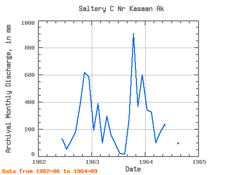
| Year | Jan | Feb | Mar | Apr | May | Jun | Jul | Aug | Sep | Oct | Nov | Dec | Annual | 1962 | 130.25 | 52.05 | 121.48 | 185.24 | 389.15 | 619.73 | 605.96 | 1963 | 199.79 | 366.97 | 100.74 | 297.26 | 158.67 | 86.10 | 21.31 | 17.62 | 272.60 | 933.35 | 366.50 | 620.03 | 3447.72 | 1964 | 354.71 | 306.53 | 101.59 | 177.83 | 239.78 | 217.09 | 92.60 | 96.28 | 176.09 |
|---|
 Return to R-Arctic Net Home Page