|
|
|||||||||||||||||
| Point ID: 9275 | Downloads | Plots | Site Data | Code: 15020500 |
|
|
|||||||||||||||||
| Download | |
|---|---|
| Site Descriptor Information | Site Time Series Data |
| Link to all available data | |
|
|
| View: | Statistics | Time Series |
| Units: | mm |
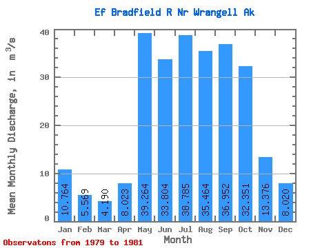
| Statistic | Jan | Feb | Mar | Apr | May | Jun | Jul | Aug | Sep | Oct | Nov | Dec | Annual |
|---|---|---|---|---|---|---|---|---|---|---|---|---|---|
| Mean | 10.76 | 5.57 | 4.19 | 8.02 | 39.26 | 33.80 | 38.78 | 35.46 | 36.95 | 32.35 | 13.38 | 8.02 | 21.19 |
| Standard Deviation | 10.01 | 0.31 | 0.33 | 4.57 | 27.67 | 7.38 | 4.51 | 2.90 | 9.05 | 13.16 | 6.05 | 0.61 | |
| Min | 3.69 | 5.35 | 3.96 | 4.79 | 23.16 | 25.42 | 33.58 | 33.22 | 28.20 | 23.05 | 9.10 | 7.58 | 21.19 |
| Max | 17.84 | 5.79 | 4.42 | 11.26 | 71.22 | 39.27 | 41.41 | 38.73 | 46.28 | 41.66 | 17.66 | 8.46 | 21.19 |
| Coefficient of Variation | 0.93 | 0.06 | 0.08 | 0.57 | 0.70 | 0.22 | 0.12 | 0.08 | 0.24 | 0.41 | 0.45 | 0.08 |
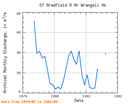
| Year | Jan | Feb | Mar | Apr | May | Jun | Jul | Aug | Sep | Oct | Nov | Dec | Annual | 1979 | 71.22 | 39.27 | 41.41 | 34.44 | 36.38 | 23.05 | 9.10 | 8.46 | 1980 | 3.69 | 5.79 | 3.96 | 11.26 | 23.16 | 36.72 | 41.37 | 33.22 | 28.20 | 41.66 | 17.66 | 7.58 | 21.19 | 1981 | 17.84 | 5.35 | 4.42 | 4.79 | 23.42 | 25.42 | 33.58 | 38.73 | 46.28 |
|---|
 Return to R-Arctic Net Home Page