|
|
|||||||||||||||||
| Point ID: 9275 | Downloads | Plots | Site Data | Code: 15020500 |
|
|
|||||||||||||||||
| Download | |
|---|---|
| Site Descriptor Information | Site Time Series Data |
| Link to all available data | |
|
|
| View: | Statistics | Time Series |
| Units: | m3/s |
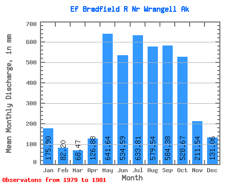
| Statistic | Jan | Feb | Mar | Apr | May | Jun | Jul | Aug | Sep | Oct | Nov | Dec | Annual |
|---|---|---|---|---|---|---|---|---|---|---|---|---|---|
| Mean | 175.87 | 82.91 | 68.47 | 126.88 | 641.55 | 534.60 | 633.72 | 579.45 | 584.38 | 528.60 | 211.54 | 131.04 | 4079.97 |
| Standard Deviation | 163.51 | 4.68 | 5.31 | 72.30 | 452.14 | 116.64 | 73.71 | 47.34 | 143.15 | 215.02 | 95.68 | 10.05 | |
| Min | 60.25 | 79.60 | 64.72 | 75.75 | 378.35 | 401.94 | 548.61 | 542.75 | 446.00 | 376.56 | 143.88 | 123.94 | 4079.97 |
| Max | 291.49 | 86.22 | 72.22 | 178.01 | 1163.63 | 621.12 | 676.56 | 632.88 | 731.87 | 680.64 | 279.20 | 138.15 | 4079.97 |
| Coefficient of Variation | 0.93 | 0.06 | 0.08 | 0.57 | 0.70 | 0.22 | 0.12 | 0.08 | 0.24 | 0.41 | 0.45 | 0.08 |
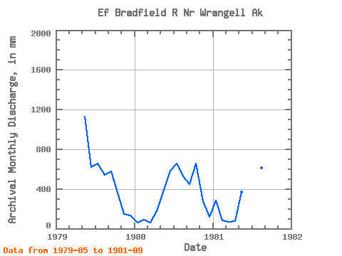
| Year | Jan | Feb | Mar | Apr | May | Jun | Jul | Aug | Sep | Oct | Nov | Dec | Annual | 1979 | 1163.63 | 621.12 | 676.56 | 562.72 | 575.27 | 376.56 | 143.88 | 138.15 | 1980 | 60.25 | 86.22 | 64.72 | 178.01 | 378.35 | 580.73 | 676.00 | 542.75 | 446.00 | 680.64 | 279.20 | 123.94 | 4079.97 | 1981 | 291.49 | 79.60 | 72.22 | 75.75 | 382.66 | 401.94 | 548.61 | 632.88 | 731.87 |
|---|
 Return to R-Arctic Net Home Page