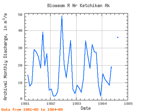
| Point ID: 9266 | Downloads | Plots | Site Data | Code: 15011894 |
| Download | |
|---|---|
| Site Descriptor Information | Site Time Series Data |
| Link to all available data | |

|

|
| View: | Statistics | Time Series |
| Units: | mm |
| Statistic | Jan | Feb | Mar | Apr | May | Jun | Jul | Aug | Sep | Oct | Nov | Dec | Annual |
|---|---|---|---|---|---|---|---|---|---|---|---|---|---|
| Mean | 9.99 | 8.81 | 6.25 | 8.77 | 26.50 | 34.08 | 26.50 | 24.86 | 27.86 | 27.20 | 13.92 | 3.84 | 16.56 |
| Standard Deviation | 4.50 | 5.38 | 3.53 | 3.05 | 6.65 | 10.30 | 10.76 | 11.03 | 7.98 | 7.30 | 11.18 | 1.66 | 1.11 |
| Min | 6.44 | 2.30 | 2.40 | 4.87 | 18.84 | 25.62 | 18.25 | 12.88 | 21.56 | 19.75 | 6.38 | 2.32 | 15.78 |
| Max | 15.05 | 14.35 | 10.31 | 12.23 | 34.21 | 48.44 | 42.11 | 36.13 | 39.18 | 34.34 | 26.77 | 5.61 | 17.34 |
| Coefficient of Variation | 0.45 | 0.61 | 0.56 | 0.35 | 0.25 | 0.30 | 0.41 | 0.44 | 0.29 | 0.27 | 0.80 | 0.43 | 0.07 |
| Year | Jan | Feb | Mar | Apr | May | Jun | Jul | Aug | Sep | Oct | Nov | Dec | Annual | 1981 | 14.35 | 7.90 | 9.52 | 29.15 | 27.75 | 24.82 | 18.37 | 39.18 | 19.75 | 26.77 | 5.61 | 1982 | 6.44 | 2.30 | 2.40 | 4.87 | 23.79 | 48.44 | 20.81 | 12.88 | 23.06 | 34.34 | 6.38 | 3.60 | 15.78 | 1983 | 8.48 | 6.72 | 4.40 | 12.23 | 34.21 | 25.62 | 18.25 | 32.07 | 27.65 | 27.50 | 8.62 | 2.32 | 17.34 | 1984 | 15.05 | 11.87 | 10.31 | 8.46 | 18.84 | 34.49 | 42.11 | 36.13 | 21.56 |
|---|
 Return to R-Arctic Net Home Page