|
|
|||||||||||||||||
| Point ID: 9266 | Downloads | Plots | Site Data | Code: 15011894 |
|
|
|||||||||||||||||
| Download | |
|---|---|
| Site Descriptor Information | Site Time Series Data |
| Link to all available data | |
|
|
| View: | Statistics | Time Series |
| Units: | m3/s |
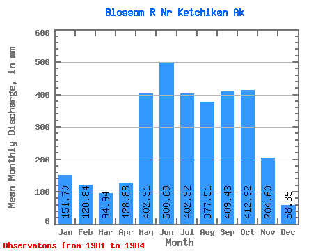
| Statistic | Jan | Feb | Mar | Apr | May | Jun | Jul | Aug | Sep | Oct | Nov | Dec | Annual |
|---|---|---|---|---|---|---|---|---|---|---|---|---|---|
| Mean | 151.67 | 121.87 | 94.93 | 128.88 | 402.25 | 500.69 | 402.26 | 377.46 | 409.43 | 412.85 | 204.60 | 58.34 | 2962.34 |
| Standard Deviation | 68.34 | 74.39 | 53.65 | 44.81 | 100.92 | 151.32 | 163.28 | 167.40 | 117.21 | 110.84 | 164.23 | 25.22 | 197.82 |
| Min | 97.79 | 31.84 | 36.43 | 71.50 | 285.96 | 376.40 | 277.05 | 195.56 | 316.78 | 299.77 | 93.81 | 35.20 | 2822.46 |
| Max | 228.55 | 198.50 | 156.53 | 179.78 | 519.35 | 711.78 | 639.32 | 548.57 | 575.71 | 521.30 | 393.28 | 85.22 | 3102.22 |
| Coefficient of Variation | 0.45 | 0.61 | 0.56 | 0.35 | 0.25 | 0.30 | 0.41 | 0.44 | 0.29 | 0.27 | 0.80 | 0.43 | 0.07 |
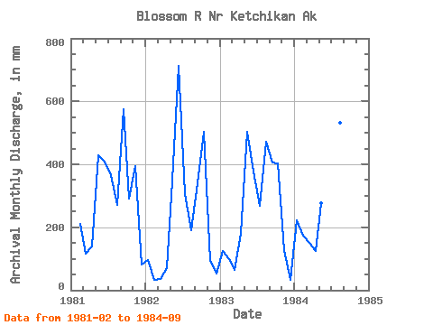
| Year | Jan | Feb | Mar | Apr | May | Jun | Jul | Aug | Sep | Oct | Nov | Dec | Annual | 1981 | 198.50 | 119.95 | 139.90 | 442.56 | 407.71 | 376.79 | 278.82 | 575.71 | 299.77 | 393.28 | 85.22 | 1982 | 97.79 | 31.84 | 36.43 | 71.50 | 361.12 | 711.78 | 315.88 | 195.56 | 338.90 | 521.30 | 93.81 | 54.60 | 2822.46 | 1983 | 128.68 | 92.98 | 66.81 | 179.78 | 519.35 | 376.40 | 277.05 | 486.89 | 406.32 | 417.48 | 126.71 | 35.20 | 3102.22 | 1984 | 228.55 | 164.17 | 156.53 | 124.35 | 285.96 | 506.86 | 639.32 | 548.57 | 316.78 |
|---|
 Return to R-Arctic Net Home Page