|
|
|||||||||||||||||
| Point ID: 9254 | Downloads | Plots | Site Data | Code: 15052495 |
|
|
|||||||||||||||||
| Download | |
|---|---|
| Site Descriptor Information | Site Time Series Data |
| Link to all available data | |
|
|
| View: | Statistics | Time Series |
| Units: | mm |
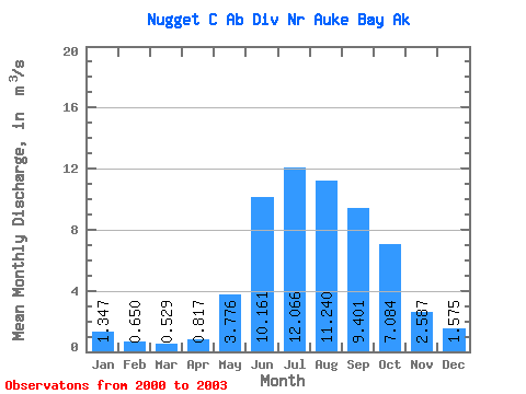
| Statistic | Jan | Feb | Mar | Apr | May | Jun | Jul | Aug | Sep | Oct | Nov | Dec | Annual |
|---|---|---|---|---|---|---|---|---|---|---|---|---|---|
| Mean | 1.35 | 0.65 | 0.53 | 0.82 | 3.78 | 10.16 | 12.07 | 11.24 | 9.40 | 7.08 | 2.59 | 1.57 | 5.11 |
| Standard Deviation | 0.47 | 0.37 | 0.23 | 0.51 | 1.11 | 3.08 | 3.92 | 3.96 | 2.27 | 3.25 | 1.44 | 0.76 | 0.77 |
| Min | 0.81 | 0.33 | 0.29 | 0.36 | 2.70 | 6.01 | 7.43 | 7.34 | 6.88 | 4.06 | 1.01 | 0.75 | 4.57 |
| Max | 1.68 | 1.06 | 0.80 | 1.53 | 5.18 | 13.47 | 16.60 | 16.29 | 12.40 | 10.52 | 3.83 | 2.25 | 5.66 |
| Coefficient of Variation | 0.35 | 0.57 | 0.44 | 0.62 | 0.29 | 0.30 | 0.33 | 0.35 | 0.24 | 0.46 | 0.56 | 0.48 | 0.15 |
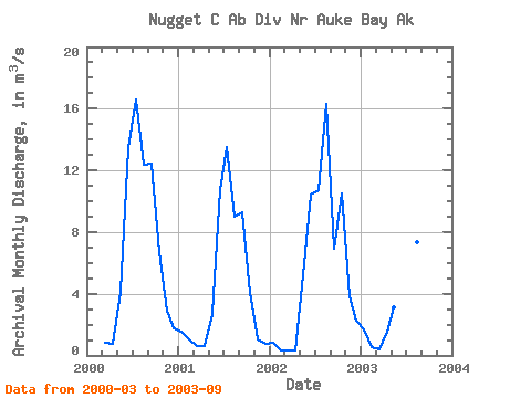
| Year | Jan | Feb | Mar | Apr | May | Jun | Jul | Aug | Sep | Oct | Nov | Dec | Annual | 2000 | 0.80 | 0.76 | 4.12 | 13.47 | 16.60 | 12.35 | 12.40 | 6.67 | 2.92 | 1.72 | 2001 | 1.56 | 1.06 | 0.63 | 0.62 | 2.70 | 10.70 | 13.51 | 8.98 | 9.26 | 4.06 | 1.01 | 0.75 | 4.57 | 2002 | 0.81 | 0.33 | 0.29 | 0.36 | 5.18 | 10.46 | 10.72 | 16.29 | 6.88 | 10.52 | 3.83 | 2.25 | 5.66 | 2003 | 1.68 | 0.57 | 0.38 | 1.53 | 3.11 | 6.01 | 7.43 | 7.34 | 9.06 |
|---|
 Return to R-Arctic Net Home Page