|
|
|||||||||||||||||
| Point ID: 9254 | Downloads | Plots | Site Data | Code: 15052495 |
|
|
|||||||||||||||||
| Download | |
|---|---|
| Site Descriptor Information | Site Time Series Data |
| Link to all available data | |
|
|
| View: | Statistics | Time Series |
| Units: | m3/s |
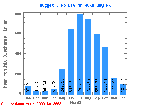
| Statistic | Jan | Feb | Mar | Apr | May | Jun | Jul | Aug | Sep | Oct | Nov | Dec | Annual |
|---|---|---|---|---|---|---|---|---|---|---|---|---|---|
| Mean | 88.22 | 38.78 | 34.62 | 51.78 | 247.27 | 643.93 | 790.03 | 735.97 | 595.79 | 463.86 | 163.94 | 103.15 | 3946.31 |
| Standard Deviation | 30.93 | 22.16 | 15.22 | 32.05 | 72.81 | 195.53 | 256.43 | 259.13 | 143.97 | 212.82 | 91.15 | 49.73 | 594.90 |
| Min | 52.81 | 19.50 | 19.34 | 22.59 | 176.50 | 381.10 | 486.43 | 480.81 | 436.26 | 265.91 | 64.06 | 49.34 | 3525.65 |
| Max | 109.99 | 62.98 | 52.66 | 97.15 | 339.30 | 853.97 | 1087.18 | 1066.29 | 786.02 | 688.95 | 242.62 | 147.43 | 4366.97 |
| Coefficient of Variation | 0.35 | 0.57 | 0.44 | 0.62 | 0.29 | 0.30 | 0.33 | 0.35 | 0.24 | 0.46 | 0.56 | 0.48 | 0.15 |
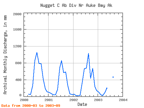
| Year | Jan | Feb | Mar | Apr | May | Jun | Jul | Aug | Sep | Oct | Nov | Dec | Annual | 2000 | 52.66 | 48.22 | 269.80 | 853.97 | 1087.18 | 808.87 | 786.02 | 436.73 | 185.14 | 112.67 | 2001 | 101.85 | 62.98 | 41.39 | 39.18 | 176.50 | 677.86 | 884.85 | 587.92 | 586.58 | 265.91 | 64.06 | 49.34 | 3525.65 | 2002 | 52.81 | 19.50 | 19.34 | 22.59 | 339.30 | 662.79 | 701.65 | 1066.29 | 436.26 | 688.95 | 242.62 | 147.43 | 4366.97 | 2003 | 109.99 | 33.85 | 25.11 | 97.15 | 203.47 | 381.10 | 486.43 | 480.81 | 574.32 |
|---|
 Return to R-Arctic Net Home Page