|
|
|||||||||||||||||
| Point ID: 9251 | Downloads | Plots | Site Data | Code: 15052000 |
|
|
|||||||||||||||||
| Download | |
|---|---|
| Site Descriptor Information | Site Time Series Data |
| Link to all available data | |
| View: | Time Series | All |
| Units: | m3/s |
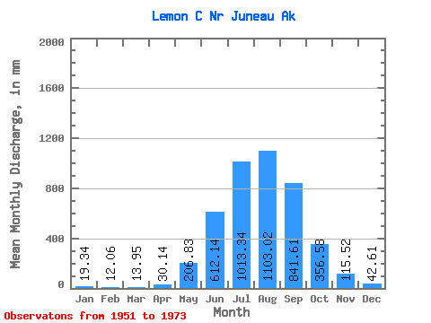
| Statistic | Jan | Feb | Mar | Apr | May | Jun | Jul | Aug | Sep | Oct | Nov | Dec | Annual |
|---|---|---|---|---|---|---|---|---|---|---|---|---|---|
| Mean | 19.38 | 12.13 | 13.96 | 30.16 | 206.79 | 612.14 | 1013.16 | 1102.83 | 841.60 | 356.52 | 115.49 | 42.65 | 4397.03 |
| Standard Deviation | 13.02 | 7.11 | 12.03 | 13.04 | 83.27 | 154.90 | 143.66 | 222.10 | 222.66 | 166.31 | 77.93 | 38.04 | 468.85 |
| Min | 3.59 | 2.18 | 3.59 | 10.52 | 103.16 | 369.96 | 751.38 | 784.90 | 480.56 | 123.17 | 38.42 | 11.41 | 3439.03 |
| Max | 62.45 | 30.07 | 56.82 | 54.88 | 458.29 | 895.46 | 1348.75 | 1739.62 | 1274.49 | 847.34 | 301.87 | 162.32 | 5530.01 |
| Coefficient of Variation | 0.67 | 0.59 | 0.86 | 0.43 | 0.40 | 0.25 | 0.14 | 0.20 | 0.27 | 0.47 | 0.68 | 0.89 | 0.11 |
 Return to R-Arctic Net Home Page