|
|
|||||||||||||||||
| Point ID: 9251 | Downloads | Plots | Site Data | Code: 15052000 |
|
|
|||||||||||||||||
| Download | |
|---|---|
| Site Descriptor Information | Site Time Series Data |
| Link to all available data | |
| View: | Time Series | All |
| Units: | mm |
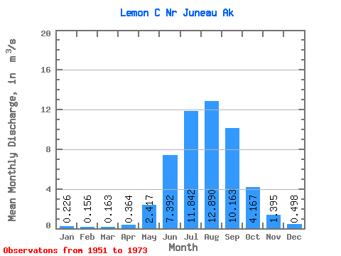
| Statistic | Jan | Feb | Mar | Apr | May | Jun | Jul | Aug | Sep | Oct | Nov | Dec | Annual |
|---|---|---|---|---|---|---|---|---|---|---|---|---|---|
| Mean | 0.23 | 0.16 | 0.16 | 0.36 | 2.42 | 7.39 | 11.84 | 12.89 | 10.16 | 4.17 | 1.40 | 0.50 | 4.36 |
| Standard Deviation | 0.15 | 0.09 | 0.14 | 0.16 | 0.97 | 1.87 | 1.68 | 2.60 | 2.69 | 1.94 | 0.94 | 0.45 | 0.47 |
| Min | 0.04 | 0.03 | 0.04 | 0.13 | 1.21 | 4.47 | 8.78 | 9.17 | 5.80 | 1.44 | 0.46 | 0.13 | 3.41 |
| Max | 0.73 | 0.39 | 0.66 | 0.66 | 5.36 | 10.81 | 15.76 | 20.33 | 15.39 | 9.90 | 3.65 | 1.90 | 5.48 |
| Coefficient of Variation | 0.67 | 0.59 | 0.86 | 0.43 | 0.40 | 0.25 | 0.14 | 0.20 | 0.27 | 0.47 | 0.68 | 0.89 | 0.11 |
 Return to R-Arctic Net Home Page