|
|
|||||||||||||||||
| Point ID: 9236 | Downloads | Plots | Site Data | Code: 15211500 |
|
|
|||||||||||||||||
| Download | |
|---|---|
| Site Descriptor Information | Site Time Series Data |
| Link to all available data | |
|
|
| View: | Statistics | Time Series |
| Units: | mm |
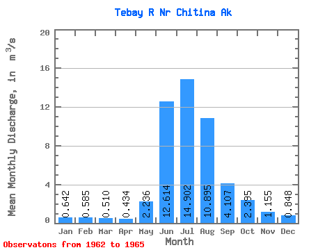
| Statistic | Jan | Feb | Mar | Apr | May | Jun | Jul | Aug | Sep | Oct | Nov | Dec | Annual |
|---|---|---|---|---|---|---|---|---|---|---|---|---|---|
| Mean | 0.64 | 0.58 | 0.51 | 0.43 | 2.24 | 12.61 | 14.90 | 10.89 | 4.11 | 2.40 | 1.16 | 0.85 | 4.60 |
| Standard Deviation | 0.16 | 0.07 | 0.06 | 0.03 | 1.75 | 6.53 | 2.36 | 3.07 | 0.51 | 0.10 | 0.18 | 0.09 | 0.30 |
| Min | 0.48 | 0.51 | 0.45 | 0.40 | 1.22 | 7.59 | 13.11 | 8.45 | 3.75 | 2.30 | 0.99 | 0.76 | 4.39 |
| Max | 0.79 | 0.65 | 0.57 | 0.45 | 4.26 | 19.99 | 17.58 | 14.34 | 4.70 | 2.50 | 1.34 | 0.93 | 4.82 |
| Coefficient of Variation | 0.24 | 0.12 | 0.11 | 0.08 | 0.78 | 0.52 | 0.16 | 0.28 | 0.12 | 0.04 | 0.15 | 0.10 | 0.07 |
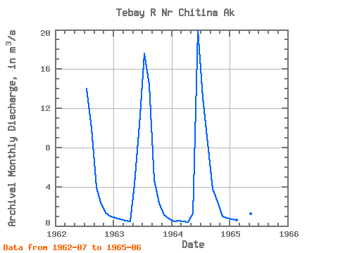
| Year | Jan | Feb | Mar | Apr | May | Jun | Jul | Aug | Sep | Oct | Nov | Dec | Annual | 1962 | 14.02 | 9.89 | 3.88 | 2.38 | 1.34 | 0.93 | 1963 | 0.79 | 0.65 | 0.57 | 0.45 | 4.26 | 10.26 | 17.58 | 14.34 | 4.70 | 2.30 | 1.13 | 0.76 | 4.82 | 1964 | 0.48 | 0.51 | 0.45 | 0.40 | 1.22 | 19.99 | 13.11 | 8.45 | 3.75 | 2.50 | 0.99 | 0.85 | 4.39 | 1965 | 0.65 | 0.59 | 0.51 | 0.45 | 1.22 | 7.59 |
|---|
 Return to R-Arctic Net Home Page