|
|
|||||||||||||||||
| Point ID: 9236 | Downloads | Plots | Site Data | Code: 15211500 |
|
|
|||||||||||||||||
| Download | |
|---|---|
| Site Descriptor Information | Site Time Series Data |
| Link to all available data | |
|
|
| View: | Statistics | Time Series |
| Units: | m3/s |
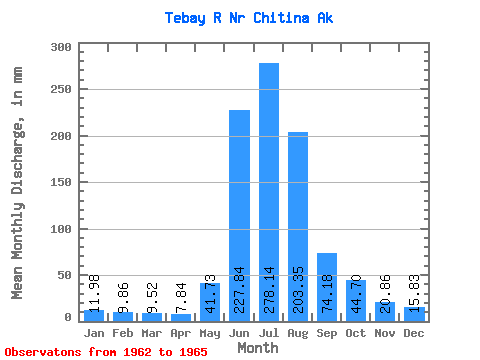
| Statistic | Jan | Feb | Mar | Apr | May | Jun | Jul | Aug | Sep | Oct | Nov | Dec | Annual |
|---|---|---|---|---|---|---|---|---|---|---|---|---|---|
| Mean | 11.97 | 9.95 | 9.51 | 7.84 | 41.72 | 227.85 | 278.11 | 203.33 | 74.18 | 44.70 | 20.86 | 15.83 | 1012.63 |
| Standard Deviation | 2.92 | 1.21 | 1.05 | 0.59 | 32.70 | 117.90 | 44.11 | 57.33 | 9.29 | 1.82 | 3.18 | 1.62 | 66.07 |
| Min | 8.98 | 8.67 | 8.45 | 7.15 | 22.84 | 137.08 | 244.66 | 157.68 | 67.72 | 42.99 | 17.90 | 14.20 | 965.91 |
| Max | 14.80 | 11.07 | 10.56 | 8.18 | 79.48 | 361.10 | 328.10 | 267.67 | 84.82 | 46.61 | 24.23 | 17.43 | 1059.35 |
| Coefficient of Variation | 0.24 | 0.12 | 0.11 | 0.08 | 0.78 | 0.52 | 0.16 | 0.28 | 0.12 | 0.04 | 0.15 | 0.10 | 0.07 |
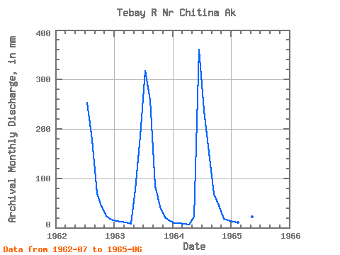
| Year | Jan | Feb | Mar | Apr | May | Jun | Jul | Aug | Sep | Oct | Nov | Dec | Annual | 1962 | 261.57 | 184.63 | 69.99 | 44.49 | 24.23 | 17.43 | 1963 | 14.80 | 11.07 | 10.56 | 8.18 | 79.48 | 185.36 | 328.10 | 267.67 | 84.82 | 42.99 | 20.46 | 14.20 | 1059.35 | 1964 | 8.98 | 8.67 | 8.45 | 7.15 | 22.84 | 361.10 | 244.66 | 157.68 | 67.72 | 46.61 | 17.90 | 15.86 | 965.91 | 1965 | 12.15 | 10.12 | 9.52 | 8.18 | 22.84 | 137.08 |
|---|
 Return to R-Arctic Net Home Page