|
|
|||||||||||||||||
| Point ID: 9226 | Downloads | Plots | Site Data | Code: 15215990 |
|
|
|||||||||||||||||
| Download | |
|---|---|
| Site Descriptor Information | Site Time Series Data |
| Link to all available data | |
|
|
| View: | Statistics | Time Series |
| Units: | mm |
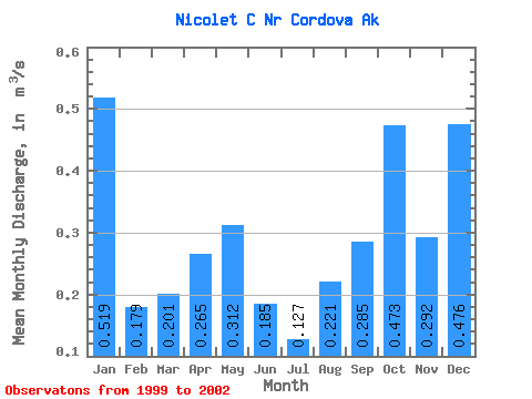
| Statistic | Jan | Feb | Mar | Apr | May | Jun | Jul | Aug | Sep | Oct | Nov | Dec | Annual |
|---|---|---|---|---|---|---|---|---|---|---|---|---|---|
| Mean | 0.52 | 0.18 | 0.20 | 0.27 | 0.31 | 0.18 | 0.13 | 0.22 | 0.28 | 0.47 | 0.29 | 0.48 | 0.30 |
| Standard Deviation | 0.22 | 0.13 | 0.11 | 0.07 | 0.10 | 0.12 | 0.08 | 0.14 | 0.04 | 0.15 | 0.15 | 0.17 | 0.06 |
| Min | 0.31 | 0.06 | 0.08 | 0.17 | 0.23 | 0.04 | 0.02 | 0.14 | 0.25 | 0.29 | 0.20 | 0.28 | 0.26 |
| Max | 0.75 | 0.32 | 0.29 | 0.32 | 0.45 | 0.27 | 0.19 | 0.38 | 0.32 | 0.57 | 0.46 | 0.58 | 0.34 |
| Coefficient of Variation | 0.43 | 0.73 | 0.55 | 0.27 | 0.32 | 0.66 | 0.60 | 0.62 | 0.13 | 0.33 | 0.50 | 0.35 | 0.19 |
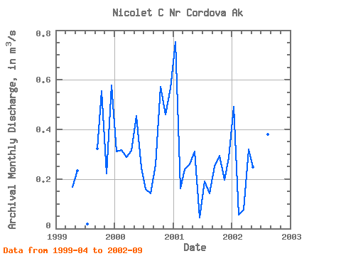
| Year | Jan | Feb | Mar | Apr | May | Jun | Jul | Aug | Sep | Oct | Nov | Dec | Annual | 1999 | 0.17 | 0.23 | 0.02 | 0.32 | 0.55 | 0.22 | 0.58 | 2000 | 0.31 | 0.32 | 0.29 | 0.32 | 0.45 | 0.24 | 0.16 | 0.14 | 0.26 | 0.57 | 0.46 | 0.57 | 0.34 | 2001 | 0.75 | 0.16 | 0.24 | 0.26 | 0.31 | 0.04 | 0.19 | 0.14 | 0.25 | 0.29 | 0.20 | 0.28 | 0.26 | 2002 | 0.49 | 0.06 | 0.08 | 0.32 | 0.25 | 0.27 | 0.14 | 0.38 | 0.31 |
|---|
 Return to R-Arctic Net Home Page