|
|
|||||||||||||||||
| Point ID: 9226 | Downloads | Plots | Site Data | Code: 15215990 |
|
|
|||||||||||||||||
| Download | |
|---|---|
| Site Descriptor Information | Site Time Series Data |
| Link to all available data | |
|
|
| View: | Statistics | Time Series |
| Units: | m3/s |
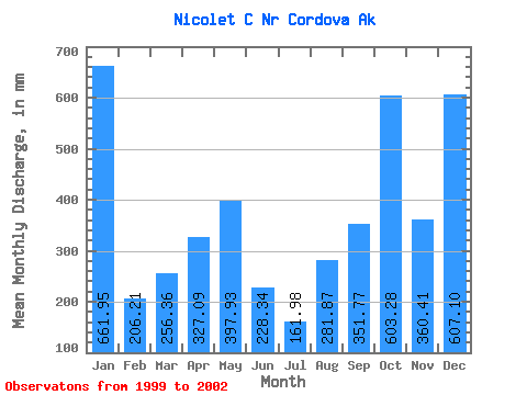
| Statistic | Jan | Feb | Mar | Apr | May | Jun | Jul | Aug | Sep | Oct | Nov | Dec | Annual |
|---|---|---|---|---|---|---|---|---|---|---|---|---|---|
| Mean | 661.66 | 207.85 | 256.95 | 327.23 | 397.97 | 227.82 | 162.27 | 281.55 | 351.77 | 603.09 | 360.93 | 606.73 | 4515.40 |
| Standard Deviation | 285.17 | 151.90 | 141.00 | 87.56 | 127.94 | 149.85 | 96.73 | 174.56 | 44.88 | 197.78 | 180.22 | 211.23 | 848.51 |
| Min | 394.79 | 65.90 | 98.48 | 206.13 | 299.68 | 55.42 | 22.95 | 179.27 | 309.23 | 375.04 | 240.28 | 362.95 | 3915.42 |
| Max | 962.15 | 368.04 | 368.54 | 393.94 | 579.53 | 326.84 | 244.85 | 483.11 | 398.22 | 727.79 | 568.10 | 735.48 | 5115.39 |
| Coefficient of Variation | 0.43 | 0.73 | 0.55 | 0.27 | 0.32 | 0.66 | 0.60 | 0.62 | 0.13 | 0.33 | 0.50 | 0.35 | 0.19 |
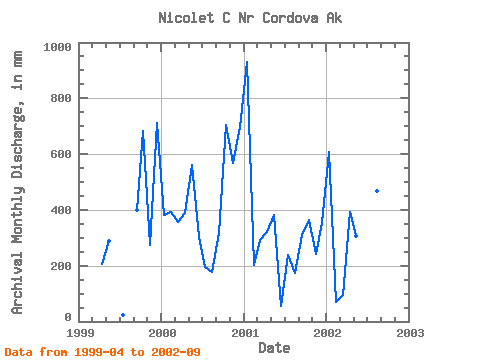
| Year | Jan | Feb | Mar | Apr | May | Jun | Jul | Aug | Sep | Oct | Nov | Dec | Annual | 1999 | 206.13 | 299.68 | 22.95 | 398.22 | 706.44 | 274.42 | 735.48 | 2000 | 394.79 | 368.04 | 368.54 | 389.09 | 579.53 | 301.21 | 201.49 | 182.28 | 317.66 | 727.79 | 568.10 | 721.74 | 5115.39 | 2001 | 962.15 | 189.60 | 303.84 | 319.76 | 395.12 | 55.42 | 244.85 | 179.27 | 309.23 | 375.04 | 240.28 | 362.95 | 3915.42 | 2002 | 628.03 | 65.90 | 98.48 | 393.94 | 317.53 | 326.84 | 179.81 | 483.11 | 381.97 |
|---|
 Return to R-Arctic Net Home Page