|
|
|||||||||||||||||
| Point ID: 9213 | Downloads | Plots | Site Data | Code: 15214000 |
|
|
|||||||||||||||||
| Download | |
|---|---|
| Site Descriptor Information | Site Time Series Data |
| Link to all available data | |
|
|
| View: | Statistics | Time Series |
| Units: | mm |
| Statistic | Jan | Feb | Mar | Apr | May | Jun | Jul | Aug | Sep | Oct | Nov | Dec | Annual |
|---|---|---|---|---|---|---|---|---|---|---|---|---|---|
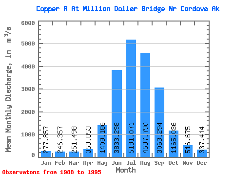
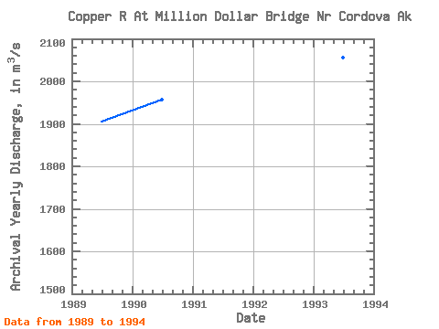
| Mean | 277.86 | 246.36 | 251.50 | 353.85 | 1409.19 | 3833.30 | 5181.07 | 4597.79 | 3063.29 | 1165.04 | 516.67 | 337.41 | 1774.41 |
| Standard Deviation | 39.22 | 32.11 | 35.50 | 73.98 | 418.48 | 242.06 | 404.07 | 610.61 | 1165.71 | 557.19 | 130.51 | 74.19 | 225.12 |
| Min | 221.51 | 190.13 | 190.45 | 287.89 | 911.25 | 3589.35 | 4369.02 | 3754.27 | 1561.30 | 600.13 | 359.62 | 283.17 | 1548.29 |
| Max | 351.68 | 269.01 | 284.08 | 472.89 | 1997.62 | 4236.20 | 5551.93 | 5323.57 | 5051.73 | 2275.67 | 728.69 | 480.47 | 2056.85 |
| Coefficient of Variation | 0.14 | 0.13 | 0.14 | 0.21 | 0.30 | 0.06 | 0.08 | 0.13 | 0.38 | 0.48 | 0.25 | 0.22 | 0.13 |
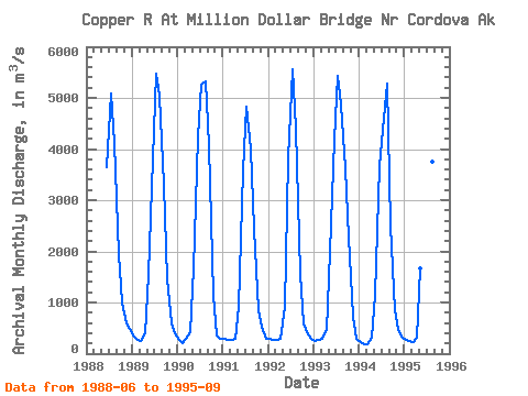
| Year | Jan | Feb | Mar | Apr | May | Jun | Jul | Aug | Sep | Oct | Nov | Dec | Annual | 1988 | 3652.87 | 5088.81 | 4114.16 | 1954.81 | 999.31 | 585.22 | 480.47 | 1989 | 351.68 | 262.44 | 240.69 | 403.51 | 1538.24 | 3812.39 | 5480.68 | 5042.23 | 3298.72 | 1452.29 | 582.76 | 395.70 | 1905.11 | 1990 | 273.39 | 211.06 | 281.16 | 410.31 | 1663.66 | 4236.20 | 5259.63 | 5323.57 | 4065.64 | 1128.38 | 359.62 | 283.17 | 1957.98 | 1991 | 283.17 | 269.01 | 271.75 | 287.89 | 919.84 | 3589.35 | 4838.53 | 4002.36 | 2451.01 | 851.24 | 518.48 | 296.87 | 1548.29 | 1992 | 283.17 | 269.01 | 271.75 | 288.83 | 911.25 | 3815.13 | 5551.93 | 4395.51 | 1561.30 | 600.13 | 370.01 | 284.08 | 1550.18 | 1993 | 254.85 | 265.98 | 284.08 | 472.89 | 1997.62 | 4172.96 | 5440.49 | 4864.10 | 3626.63 | 2275.67 | 728.69 | 298.24 | 2056.85 | 1994 | 221.51 | 190.13 | 190.45 | 307.71 | 1156.51 | 3675.24 | 4369.02 | 5286.12 | 2496.51 | 848.23 | 471.95 | 323.36 | 1628.06 | 1995 | 277.23 | 256.87 | 220.60 | 305.82 | 1677.18 | 3712.24 | 5419.48 | 3754.27 | 5051.73 |
|---|
 Return to R-Arctic Net Home Page