|
|
|||||||||||||||||
| Point ID: 9213 | Downloads | Plots | Site Data | Code: 15214000 |
|
|
|||||||||||||||||
| Download | |
|---|---|
| Site Descriptor Information | Site Time Series Data |
| Link to all available data | |
|
|
| View: | Statistics | Time Series |
| Units: | m3/s |
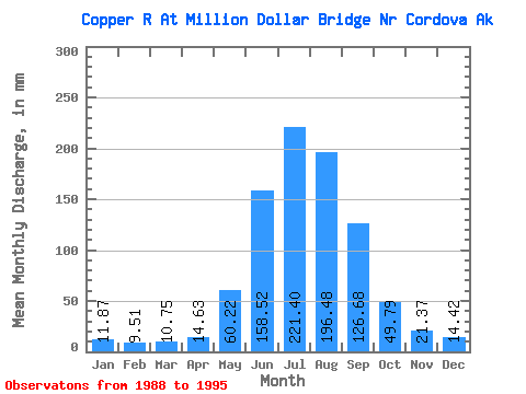
| Statistic | Jan | Feb | Mar | Apr | May | Jun | Jul | Aug | Sep | Oct | Nov | Dec | Annual |
|---|---|---|---|---|---|---|---|---|---|---|---|---|---|
| Mean | 11.87 | 9.59 | 10.75 | 14.63 | 60.21 | 158.52 | 221.37 | 196.45 | 126.68 | 49.78 | 21.37 | 14.42 | 893.47 |
| Standard Deviation | 1.68 | 1.25 | 1.52 | 3.06 | 17.88 | 10.01 | 17.26 | 26.09 | 48.21 | 23.81 | 5.40 | 3.17 | 113.35 |
| Min | 9.46 | 7.40 | 8.14 | 11.90 | 38.94 | 148.44 | 186.67 | 160.41 | 64.57 | 25.64 | 14.87 | 12.10 | 779.61 |
| Max | 15.03 | 10.47 | 12.14 | 19.56 | 85.35 | 175.19 | 237.22 | 227.46 | 208.91 | 97.23 | 30.13 | 20.53 | 1035.68 |
| Coefficient of Variation | 0.14 | 0.13 | 0.14 | 0.21 | 0.30 | 0.06 | 0.08 | 0.13 | 0.38 | 0.48 | 0.25 | 0.22 | 0.13 |
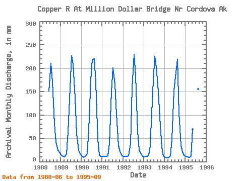
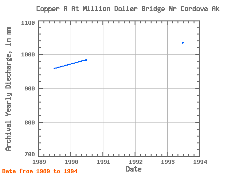
| Year | Jan | Feb | Mar | Apr | May | Jun | Jul | Aug | Sep | Oct | Nov | Dec | Annual | 1988 | 151.06 | 217.43 | 175.78 | 80.84 | 42.70 | 24.20 | 20.53 | 1989 | 15.03 | 10.22 | 10.28 | 16.69 | 65.72 | 157.66 | 234.17 | 215.44 | 136.42 | 62.05 | 24.10 | 16.91 | 959.28 | 1990 | 11.68 | 8.22 | 12.01 | 16.97 | 71.08 | 175.19 | 224.73 | 227.46 | 168.13 | 48.21 | 14.87 | 12.10 | 985.90 | 1991 | 12.10 | 10.47 | 11.61 | 11.90 | 39.30 | 148.44 | 206.73 | 171.01 | 101.36 | 36.37 | 21.44 | 12.68 | 779.61 | 1992 | 12.10 | 10.47 | 11.61 | 11.94 | 38.94 | 157.77 | 237.22 | 187.81 | 64.57 | 25.64 | 15.30 | 12.14 | 780.56 | 1993 | 10.89 | 10.35 | 12.14 | 19.56 | 85.35 | 172.57 | 232.45 | 207.83 | 149.98 | 97.23 | 30.13 | 12.74 | 1035.68 | 1994 | 9.46 | 7.40 | 8.14 | 12.72 | 49.41 | 151.99 | 186.67 | 225.86 | 103.24 | 36.24 | 19.52 | 13.82 | 819.77 | 1995 | 11.85 | 10.00 | 9.43 | 12.65 | 71.66 | 153.52 | 231.56 | 160.41 | 208.91 |
|---|
 Return to R-Arctic Net Home Page