|
|
|||||||||||||||||
| Point ID: 9202 | Downloads | Plots | Site Data | Code: 1523849020 |
|
|
|||||||||||||||||
| Download | |
|---|---|
| Site Descriptor Information | Site Time Series Data |
| Link to all available data | |
|
|
| View: | Statistics | Time Series |
| Units: | mm |
| Statistic | Jan | Feb | Mar | Apr | May | Jun | Jul | Aug | Sep | Oct | Nov | Dec | Annual |
|---|---|---|---|---|---|---|---|---|---|---|---|---|---|
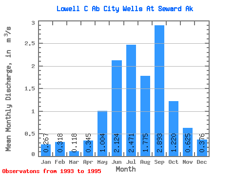
| Mean | 0.27 | 0.32 | 0.12 | 0.34 | 1.00 | 2.12 | 2.47 | 1.77 | 2.89 | 1.22 | 0.62 | 0.38 | 1.09 |
| Standard Deviation | 0.03 | 0.12 | 0.10 | 0.02 | 0.20 | 0.31 | 0.72 | 0.16 | 1.70 | 0.20 | 0.01 | 0.05 | |
| Min | 0.25 | 0.23 | 0.05 | 0.33 | 0.86 | 1.90 | 1.96 | 1.66 | 1.69 | 1.08 | 0.62 | 0.34 | 1.09 |
| Max | 0.29 | 0.41 | 0.19 | 0.36 | 1.14 | 2.35 | 2.98 | 1.89 | 4.09 | 1.36 | 0.63 | 0.41 | 1.09 |
| Coefficient of Variation | 0.11 | 0.39 | 0.86 | 0.05 | 0.20 | 0.15 | 0.29 | 0.09 | 0.59 | 0.17 | 0.02 | 0.13 |
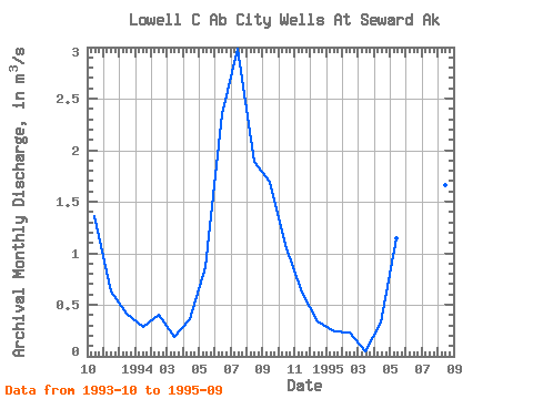
| Year | Jan | Feb | Mar | Apr | May | Jun | Jul | Aug | Sep | Oct | Nov | Dec | Annual | 1993 | 1.36 | 0.63 | 0.41 | 1994 | 0.29 | 0.41 | 0.19 | 0.36 | 0.86 | 2.35 | 2.98 | 1.89 | 1.69 | 1.08 | 0.62 | 0.34 | 1.09 | 1995 | 0.25 | 0.23 | 0.05 | 0.33 | 1.14 | 1.90 | 1.96 | 1.66 | 4.09 |
|---|
 Return to R-Arctic Net Home Page