|
|
|||||||||||||||||
| Point ID: 9202 | Downloads | Plots | Site Data | Code: 1523849020 |
|
|
|||||||||||||||||
| Download | |
|---|---|
| Site Descriptor Information | Site Time Series Data |
| Link to all available data | |
|
|
| View: | Statistics | Time Series |
| Units: | m3/s |
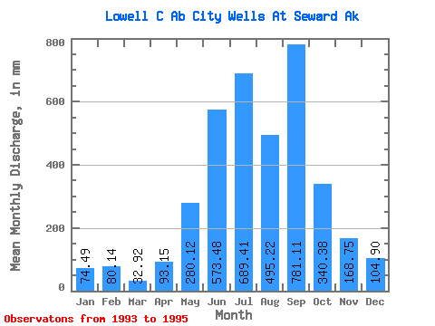
| Statistic | Jan | Feb | Mar | Apr | May | Jun | Jul | Aug | Sep | Oct | Nov | Dec | Annual |
|---|---|---|---|---|---|---|---|---|---|---|---|---|---|
| Mean | 74.38 | 80.79 | 32.95 | 93.12 | 280.02 | 573.42 | 689.31 | 495.12 | 781.13 | 340.43 | 168.84 | 104.83 | 3574.91 |
| Standard Deviation | 8.07 | 31.72 | 28.51 | 4.61 | 54.76 | 84.70 | 201.59 | 45.78 | 458.82 | 56.93 | 3.42 | 13.52 | |
| Min | 68.67 | 58.36 | 12.80 | 89.86 | 241.30 | 513.52 | 546.76 | 462.76 | 456.70 | 300.18 | 166.43 | 95.28 | 3574.91 |
| Max | 80.09 | 103.22 | 53.11 | 96.38 | 318.74 | 633.31 | 831.85 | 527.49 | 1105.56 | 380.69 | 171.26 | 114.39 | 3574.91 |
| Coefficient of Variation | 0.11 | 0.39 | 0.86 | 0.05 | 0.20 | 0.15 | 0.29 | 0.09 | 0.59 | 0.17 | 0.02 | 0.13 |
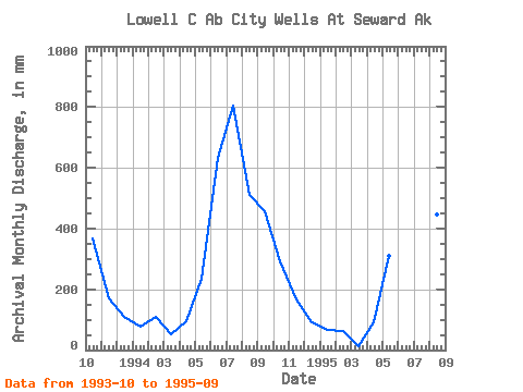
| Year | Jan | Feb | Mar | Apr | May | Jun | Jul | Aug | Sep | Oct | Nov | Dec | Annual | 1993 | 380.69 | 171.26 | 114.39 | 1994 | 80.09 | 103.22 | 53.11 | 96.38 | 241.30 | 633.31 | 831.85 | 527.49 | 456.70 | 300.18 | 166.43 | 95.28 | 3574.91 | 1995 | 68.67 | 58.36 | 12.80 | 89.86 | 318.74 | 513.52 | 546.76 | 462.76 | 1105.56 |
|---|
 Return to R-Arctic Net Home Page