|
|
|||||||||||||||||
| Point ID: 9200 | Downloads | Plots | Site Data | Code: 15237730 |
|
|
|||||||||||||||||
| Download | |
|---|---|
| Site Descriptor Information | Site Time Series Data |
| Link to all available data | |
|
|
| View: | Statistics | Time Series |
| Units: | mm |
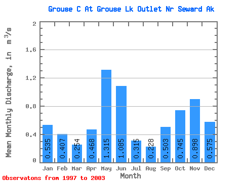
| Statistic | Jan | Feb | Mar | Apr | May | Jun | Jul | Aug | Sep | Oct | Nov | Dec | Annual |
|---|---|---|---|---|---|---|---|---|---|---|---|---|---|
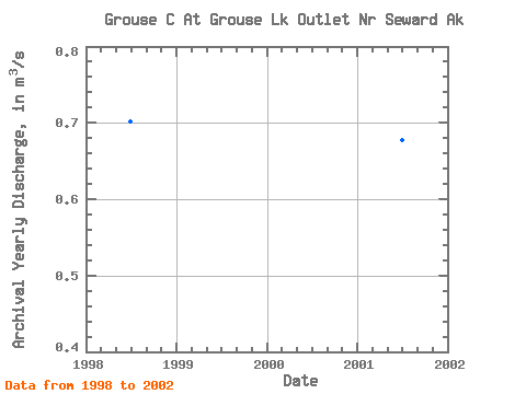
| Mean | 0.54 | 0.41 | 0.25 | 0.47 | 1.31 | 1.08 | 0.32 | 0.23 | 0.50 | 0.74 | 0.90 | 0.57 | 0.65 |
| Standard Deviation | 0.57 | 0.43 | 0.14 | 0.31 | 0.38 | 0.64 | 0.15 | 0.08 | 0.29 | 0.50 | 0.80 | 0.32 | 0.11 |
| Min | 0.15 | 0.09 | 0.08 | 0.16 | 0.85 | 0.27 | 0.17 | 0.17 | 0.19 | 0.33 | 0.21 | 0.25 | 0.49 |
| Max | 1.64 | 1.27 | 0.44 | 1.09 | 1.92 | 2.00 | 0.54 | 0.40 | 1.00 | 1.72 | 2.36 | 1.12 | 0.77 |
| Coefficient of Variation | 1.06 | 1.06 | 0.57 | 0.67 | 0.29 | 0.59 | 0.47 | 0.35 | 0.57 | 0.67 | 0.89 | 0.55 | 0.16 |
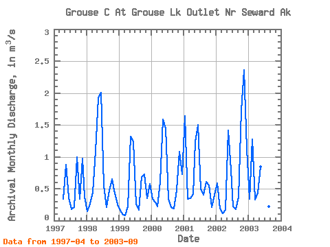
| Year | Jan | Feb | Mar | Apr | May | Jun | Jul | Aug | Sep | Oct | Nov | Dec | Annual | 1997 | 0.34 | 0.88 | 0.36 | 0.17 | 0.21 | 1.00 | 0.33 | 0.97 | 0.37 | 1998 | 0.15 | 0.26 | 0.44 | 1.09 | 1.92 | 2.00 | 0.54 | 0.20 | 0.47 | 0.65 | 0.42 | 0.25 | 0.70 | 1999 | 0.15 | 0.09 | 0.08 | 0.22 | 1.31 | 1.23 | 0.26 | 0.17 | 0.68 | 0.73 | 0.35 | 0.57 | 0.49 | 2000 | 0.34 | 0.28 | 0.22 | 0.61 | 1.59 | 1.45 | 0.34 | 0.21 | 0.19 | 0.48 | 1.08 | 0.73 | 0.63 | 2001 | 1.64 | 0.34 | 0.35 | 0.41 | 1.23 | 1.50 | 0.49 | 0.40 | 0.61 | 0.55 | 0.21 | 0.40 | 0.68 | 2002 | 0.59 | 0.19 | 0.11 | 0.16 | 1.42 | 0.79 | 0.22 | 0.18 | 0.37 | 1.72 | 2.36 | 1.12 | 0.77 | 2003 | 0.34 | 1.27 | 0.33 | 0.44 | 0.85 | 0.27 | 0.18 | 0.22 | 0.20 |
|---|
 Return to R-Arctic Net Home Page