|
|
|||||||||||||||||
| Point ID: 9200 | Downloads | Plots | Site Data | Code: 15237730 |
|
|
|||||||||||||||||
| Download | |
|---|---|
| Site Descriptor Information | Site Time Series Data |
| Link to all available data | |
|
|
| View: | Statistics | Time Series |
| Units: | m3/s |
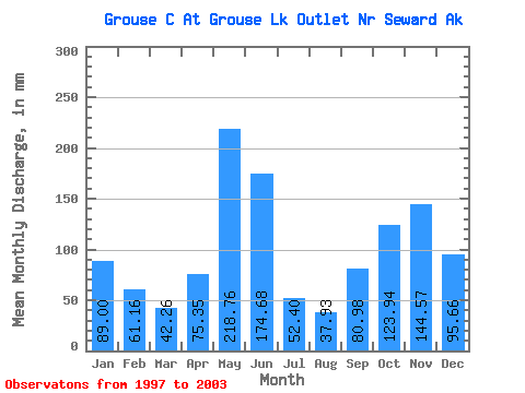
| Statistic | Jan | Feb | Mar | Apr | May | Jun | Jul | Aug | Sep | Oct | Nov | Dec | Annual |
|---|---|---|---|---|---|---|---|---|---|---|---|---|---|
| Mean | 89.05 | 61.73 | 42.19 | 75.34 | 218.66 | 174.72 | 52.32 | 37.96 | 80.94 | 123.85 | 144.53 | 95.60 | 1278.87 |
| Standard Deviation | 94.08 | 65.65 | 23.88 | 50.29 | 63.48 | 102.87 | 24.86 | 13.18 | 46.30 | 82.84 | 128.28 | 52.75 | 207.86 |
| Min | 24.62 | 14.32 | 12.66 | 26.47 | 141.00 | 43.55 | 28.78 | 28.44 | 30.37 | 55.50 | 33.80 | 41.87 | 953.97 |
| Max | 273.03 | 193.13 | 73.38 | 175.82 | 319.99 | 322.15 | 90.49 | 67.14 | 160.90 | 286.41 | 379.90 | 187.02 | 1508.63 |
| Coefficient of Variation | 1.06 | 1.06 | 0.57 | 0.67 | 0.29 | 0.59 | 0.47 | 0.35 | 0.57 | 0.67 | 0.89 | 0.55 | 0.16 |
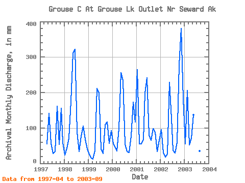
| Year | Jan | Feb | Mar | Apr | May | Jun | Jul | Aug | Sep | Oct | Nov | Dec | Annual | 1997 | 54.74 | 146.04 | 57.29 | 28.78 | 35.08 | 160.90 | 55.50 | 155.83 | 61.31 | 1998 | 24.62 | 39.85 | 73.38 | 175.82 | 319.99 | 322.15 | 90.49 | 34.13 | 76.22 | 108.67 | 67.90 | 41.87 | 1375.17 | 1999 | 25.21 | 14.32 | 12.66 | 34.87 | 218.18 | 198.61 | 42.42 | 28.44 | 109.26 | 121.09 | 56.33 | 95.43 | 953.97 | 2000 | 56.69 | 42.85 | 36.64 | 98.30 | 264.66 | 233.09 | 56.05 | 34.85 | 30.37 | 79.67 | 173.40 | 121.25 | 1227.34 | 2001 | 273.03 | 51.63 | 57.70 | 66.38 | 204.80 | 241.64 | 81.50 | 67.14 | 97.86 | 91.77 | 33.80 | 66.72 | 1329.27 | 2002 | 98.15 | 28.61 | 18.09 | 26.47 | 235.96 | 126.72 | 37.09 | 29.98 | 59.34 | 286.41 | 379.90 | 187.02 | 1508.63 | 2003 | 56.61 | 193.13 | 54.64 | 70.78 | 141.00 | 43.55 | 29.94 | 36.13 | 32.60 |
|---|
 Return to R-Arctic Net Home Page