|
|
|||||||||||||||||
| Point ID: 9192 | Downloads | Plots | Site Data | Code: 15226500 |
|
|
|||||||||||||||||
| Download | |
|---|---|
| Site Descriptor Information | Site Time Series Data |
| Link to all available data | |
|
|
| View: | Statistics | Time Series |
| Units: | mm |
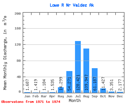
| Statistic | Jan | Feb | Mar | Apr | May | Jun | Jul | Aug | Sep | Oct | Nov | Dec | Annual |
|---|---|---|---|---|---|---|---|---|---|---|---|---|---|
| Mean | 1.69 | 1.42 | 1.18 | 1.54 | 14.30 | 54.27 | 128.42 | 109.95 | 61.19 | 11.43 | 3.35 | 2.18 | 34.04 |
| Standard Deviation | 0.11 | 0.17 | 0.39 | 0.32 | 4.30 | 6.89 | 44.36 | 28.68 | 39.46 | 5.16 | 1.27 | 0.26 | 10.13 |
| Min | 1.62 | 1.28 | 0.92 | 1.27 | 10.77 | 49.93 | 90.78 | 70.56 | 20.64 | 6.27 | 2.39 | 2.00 | 26.88 |
| Max | 1.81 | 1.61 | 1.63 | 1.88 | 19.08 | 62.22 | 177.33 | 131.54 | 95.90 | 16.58 | 4.79 | 2.48 | 41.21 |
| Coefficient of Variation | 0.07 | 0.12 | 0.33 | 0.21 | 0.30 | 0.13 | 0.34 | 0.26 | 0.65 | 0.45 | 0.38 | 0.12 | 0.30 |
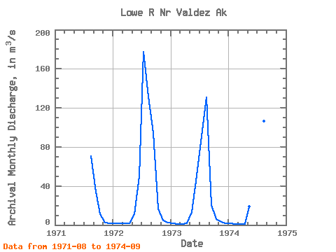
| Year | Jan | Feb | Mar | Apr | May | Jun | Jul | Aug | Sep | Oct | Nov | Dec | Annual | 1971 | 70.56 | 34.06 | 11.44 | 2.39 | 2.05 | 1972 | 1.81 | 1.61 | 1.63 | 1.88 | 10.77 | 49.93 | 177.33 | 131.54 | 94.15 | 16.58 | 4.79 | 2.48 | 41.21 | 1973 | 1.62 | 1.28 | 1.00 | 1.46 | 13.05 | 50.66 | 90.78 | 130.91 | 20.64 | 6.27 | 2.87 | 2.00 | 26.88 | 1974 | 1.63 | 1.36 | 0.92 | 1.27 | 19.08 | 62.22 | 117.16 | 106.78 | 95.90 |
|---|
 Return to R-Arctic Net Home Page