|
|
|||||||||||||||||
| Point ID: 9192 | Downloads | Plots | Site Data | Code: 15226500 |
|
|
|||||||||||||||||
| Download | |
|---|---|
| Site Descriptor Information | Site Time Series Data |
| Link to all available data | |
|
|
| View: | Statistics | Time Series |
| Units: | m3/s |
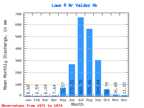
| Statistic | Jan | Feb | Mar | Apr | May | Jun | Jul | Aug | Sep | Oct | Nov | Dec | Annual |
|---|---|---|---|---|---|---|---|---|---|---|---|---|---|
| Mean | 8.68 | 6.65 | 6.09 | 7.64 | 73.55 | 270.21 | 660.61 | 565.57 | 304.64 | 58.78 | 16.68 | 11.20 | 2063.77 |
| Standard Deviation | 0.56 | 0.78 | 2.00 | 1.57 | 22.11 | 34.33 | 228.19 | 147.53 | 196.48 | 26.52 | 6.34 | 1.36 | 614.31 |
| Min | 8.34 | 6.02 | 4.75 | 6.30 | 55.38 | 248.61 | 466.97 | 362.94 | 102.75 | 32.23 | 11.89 | 10.29 | 1629.39 |
| Max | 9.33 | 7.53 | 8.39 | 9.38 | 98.16 | 309.79 | 912.18 | 676.63 | 477.47 | 85.28 | 23.87 | 12.76 | 2498.15 |
| Coefficient of Variation | 0.07 | 0.12 | 0.33 | 0.21 | 0.30 | 0.13 | 0.34 | 0.26 | 0.65 | 0.45 | 0.38 | 0.12 | 0.30 |
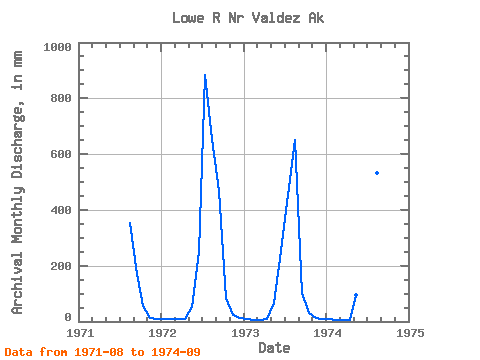
| Year | Jan | Feb | Mar | Apr | May | Jun | Jul | Aug | Sep | Oct | Nov | Dec | Annual | 1971 | 362.94 | 169.57 | 58.83 | 11.89 | 10.55 | 1972 | 9.33 | 7.53 | 8.39 | 9.38 | 55.38 | 248.61 | 912.18 | 676.63 | 468.78 | 85.28 | 23.87 | 12.76 | 2498.15 | 1973 | 8.34 | 6.02 | 5.13 | 7.26 | 67.12 | 252.22 | 466.97 | 673.43 | 102.75 | 32.23 | 14.29 | 10.29 | 1629.39 | 1974 | 8.36 | 6.40 | 4.75 | 6.30 | 98.16 | 309.79 | 602.67 | 549.29 | 477.47 |
|---|
 Return to R-Arctic Net Home Page