|
|
|||||||||||||||||
| Point ID: 9062 | Downloads | Plots | Site Data | Code: 49075 |
|
|
|||||||||||||||||
| Download | |
|---|---|
| Site Descriptor Information | Site Time Series Data |
| Link to all available data | |
|
|
| View: | Statistics | Time Series |
| Units: | mm |
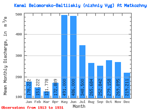
| Statistic | Jan | Feb | Mar | Apr | May | Jun | Jul | Aug | Sep | Oct | Nov | Dec | Annual |
|---|---|---|---|---|---|---|---|---|---|---|---|---|---|
| Mean | 178.22 | 151.22 | 131.78 | 172.89 | 491.00 | 486.00 | 348.50 | 265.68 | 252.84 | 279.16 | 269.89 | 219.21 | 271.26 |
| Standard Deviation | 59.80 | 46.19 | 35.49 | 80.55 | 108.09 | 110.53 | 77.31 | 76.26 | 89.40 | 88.49 | 108.86 | 77.33 | 40.65 |
| Min | 97.00 | 88.00 | 82.00 | 101.00 | 265.00 | 305.00 | 216.00 | 162.00 | 149.00 | 121.00 | 105.00 | 108.00 | 218.83 |
| Max | 309.00 | 271.00 | 226.00 | 384.00 | 670.00 | 676.00 | 460.00 | 491.00 | 463.00 | 412.00 | 474.00 | 373.00 | 362.50 |
| Coefficient of Variation | 0.34 | 0.30 | 0.27 | 0.47 | 0.22 | 0.23 | 0.22 | 0.29 | 0.35 | 0.32 | 0.40 | 0.35 | 0.15 |
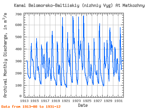
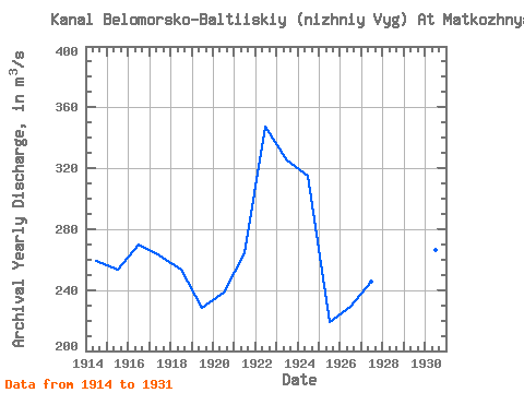
| Year | Jan | Feb | Mar | Apr | May | Jun | Jul | Aug | Sep | Oct | Nov | Dec | Annual | 1913 | 306.00 | 285.00 | 193.00 | 176.00 | 169.00 | 1914 | 163.00 | 157.00 | 160.00 | 162.00 | 356.00 | 447.00 | 332.00 | 307.00 | 316.00 | 293.00 | 216.00 | 199.00 | 259.00 | 1915 | 161.00 | 156.00 | 145.00 | 161.00 | 403.00 | 489.00 | 384.00 | 261.00 | 222.00 | 257.00 | 217.00 | 182.00 | 253.17 | 1916 | 144.00 | 129.00 | 115.00 | 108.00 | 436.00 | 404.00 | 401.00 | 281.00 | 243.00 | 322.00 | 358.00 | 298.00 | 269.92 | 1917 | 220.00 | 183.00 | 154.00 | 164.00 | 440.00 | 460.00 | 279.00 | 169.00 | 186.00 | 318.00 | 327.00 | 254.00 | 262.83 | 1918 | 206.00 | 168.00 | 139.00 | 167.00 | 483.00 | 548.00 | 416.00 | 267.00 | 188.00 | 161.00 | 158.00 | 143.00 | 253.67 | 1919 | 141.00 | 120.00 | 100.00 | 105.00 | 461.00 | 428.00 | 328.00 | 199.00 | 189.00 | 270.00 | 254.00 | 148.00 | 228.58 | 1920 | 116.00 | 99.00 | 98.00 | 384.00 | 660.00 | 505.00 | 315.00 | 198.00 | 149.00 | 121.00 | 105.00 | 108.00 | 238.17 | 1921 | 97.00 | 88.00 | 82.00 | 328.00 | 538.00 | 352.00 | 293.00 | 304.00 | 257.00 | 392.00 | 248.00 | 193.00 | 264.33 | 1922 | 163.00 | 139.00 | 124.00 | 124.00 | 670.00 | 629.00 | 444.00 | 491.00 | 433.00 | 382.00 | 327.00 | 240.00 | 347.17 | 1923 | 184.00 | 151.00 | 127.00 | 106.00 | 265.00 | 667.00 | 460.00 | 323.00 | 374.00 | 407.00 | 467.00 | 368.00 | 324.92 | 1924 | 309.00 | 271.00 | 226.00 | 265.00 | 668.00 | 676.00 | 433.00 | 263.00 | 183.00 | 188.00 | 156.00 | 144.00 | 315.17 | 1925 | 124.00 | 111.00 | 102.00 | 198.00 | 450.00 | 364.00 | 224.00 | 162.00 | 157.00 | 274.00 | 255.00 | 205.00 | 218.83 | 1926 | 153.00 | 126.00 | 111.00 | 105.00 | 489.00 | 428.00 | 321.00 | 216.00 | 203.00 | 188.00 | 188.00 | 224.00 | 229.33 | 1927 | 170.00 | 138.00 | 122.00 | 113.00 | 532.00 | 611.00 | 380.00 | 242.00 | 186.00 | 171.00 | 148.00 | 132.00 | 245.42 | 1928 | 117.00 | 104.00 | 93.00 | 101.00 | 452.00 | 305.00 | 241.00 | 268.00 | 292.00 | 329.00 | 474.00 | 373.00 | 262.42 | 1929 | 297.00 | 209.00 | 167.00 | 135.00 | 542.00 | 576.00 | 437.00 | 356.00 | 463.00 | 412.00 | 428.00 | 328.00 | 362.50 | 1930 | 254.00 | 216.00 | 175.00 | 214.00 | 415.00 | 392.00 | 216.00 | 200.00 | 237.00 | 317.00 | 320.00 | 240.00 | 266.33 | 1931 | 189.00 | 157.00 | 132.00 | 172.00 | 578.00 | 467.00 | 369.00 | 235.00 | 241.00 | 309.00 | 306.00 | 217.00 | 281.00 |
|---|
 Return to R-Arctic Net Home Page