|
|
|||||||||||||||||
| Point ID: 9062 | Downloads | Plots | Site Data | Code: 49075 |
|
|
|||||||||||||||||
| Download | |
|---|---|
| Site Descriptor Information | Site Time Series Data |
| Link to all available data | |
| View: | Time Series | All |
| Units: | mm |
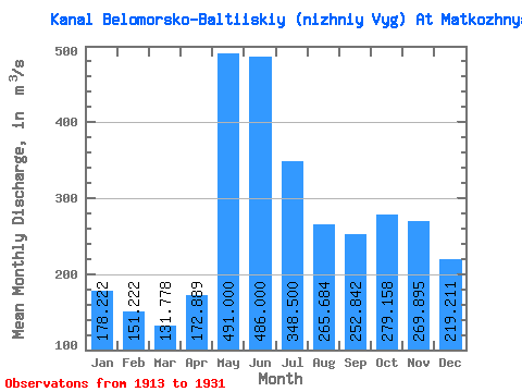
| Statistic | Jan | Feb | Mar | Apr | May | Jun | Jul | Aug | Sep | Oct | Nov | Dec | Annual |
|---|---|---|---|---|---|---|---|---|---|---|---|---|---|
| Mean | 178.22 | 151.22 | 131.78 | 172.89 | 491.00 | 486.00 | 348.50 | 265.68 | 252.84 | 279.16 | 269.89 | 219.21 | 271.26 |
| Standard Deviation | 59.80 | 46.19 | 35.49 | 80.55 | 108.09 | 110.53 | 77.31 | 76.26 | 89.40 | 88.49 | 108.86 | 77.33 | 40.65 |
| Min | 97.00 | 88.00 | 82.00 | 101.00 | 265.00 | 305.00 | 216.00 | 162.00 | 149.00 | 121.00 | 105.00 | 108.00 | 218.83 |
| Max | 309.00 | 271.00 | 226.00 | 384.00 | 670.00 | 676.00 | 460.00 | 491.00 | 463.00 | 412.00 | 474.00 | 373.00 | 362.50 |
| Coefficient of Variation | 0.34 | 0.30 | 0.27 | 0.47 | 0.22 | 0.23 | 0.22 | 0.29 | 0.35 | 0.32 | 0.40 | 0.35 | 0.15 |
 Return to R-Arctic Net Home Page