|
|
|||||||||||||||||
| Point ID: 9049 | Downloads | Plots | Site Data | Code: 49010 |
|
|
|||||||||||||||||
| Download | |
|---|---|
| Site Descriptor Information | Site Time Series Data |
| Link to all available data | |
|
|
| View: | Statistics | Time Series |
| Units: | mm |
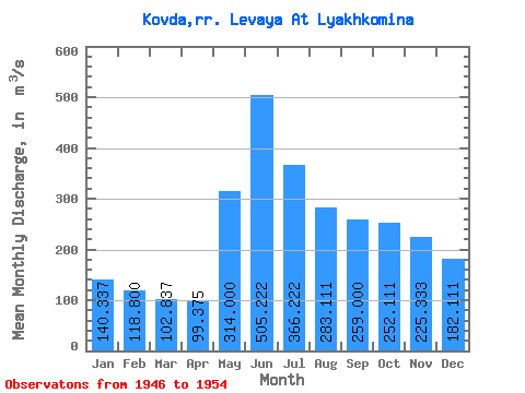
| Statistic | Jan | Feb | Mar | Apr | May | Jun | Jul | Aug | Sep | Oct | Nov | Dec | Annual |
|---|---|---|---|---|---|---|---|---|---|---|---|---|---|
| Mean | 140.34 | 118.80 | 102.84 | 99.38 | 314.00 | 505.22 | 366.22 | 283.11 | 259.00 | 252.11 | 225.33 | 182.11 | 240.76 |
| Standard Deviation | 45.33 | 30.60 | 23.07 | 20.77 | 128.75 | 154.59 | 79.63 | 77.50 | 100.29 | 123.64 | 99.62 | 69.58 | 58.52 |
| Min | 82.70 | 79.90 | 73.20 | 71.00 | 172.00 | 275.00 | 209.00 | 159.00 | 121.00 | 104.00 | 103.00 | 95.00 | 130.17 |
| Max | 202.00 | 156.00 | 128.00 | 128.00 | 476.00 | 748.00 | 464.00 | 381.00 | 394.00 | 475.00 | 350.00 | 260.00 | 309.67 |
| Coefficient of Variation | 0.32 | 0.26 | 0.22 | 0.21 | 0.41 | 0.31 | 0.22 | 0.27 | 0.39 | 0.49 | 0.44 | 0.38 | 0.24 |
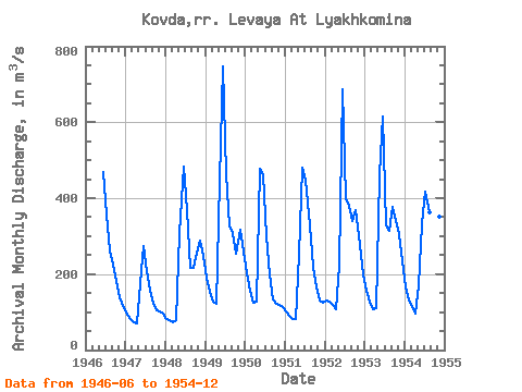
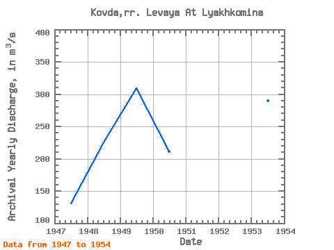
| Year | Jan | Feb | Mar | Apr | May | Jun | Jul | Aug | Sep | Oct | Nov | Dec | Annual | 1946 | 468.00 | 358.00 | 263.00 | 224.00 | 182.00 | 138.00 | 115.00 | 1947 | 92.00 | 82.00 | 74.00 | 71.00 | 177.00 | 275.00 | 209.00 | 159.00 | 121.00 | 104.00 | 103.00 | 95.00 | 130.17 | 1948 | 82.70 | 79.90 | 73.20 | 79.00 | 309.00 | 482.00 | 368.00 | 216.00 | 217.00 | 256.00 | 288.00 | 248.00 | 224.90 | 1949 | 191.00 | 152.00 | 128.00 | 122.00 | 446.00 | 748.00 | 464.00 | 325.00 | 307.00 | 255.00 | 318.00 | 260.00 | 309.67 | 1950 | 202.00 | 156.00 | 126.00 | 128.00 | 476.00 | 462.00 | 301.00 | 199.00 | 132.00 | 122.00 | 120.00 | 112.00 | 211.33 | 1951 | 103.00 | 90.50 | 81.50 | 82.50 | 250.00 | 481.00 | 450.00 | 327.00 | 220.00 | 166.00 | 131.00 | 124.00 | 208.88 | 1952 | 131.00 | 128.00 | 119.00 | 108.00 | 223.00 | 686.00 | 400.00 | 381.00 | 340.00 | 369.00 | 276.00 | 198.00 | 279.92 | 1953 | 155.00 | 128.00 | 108.00 | 109.00 | 459.00 | 614.00 | 329.00 | 315.00 | 376.00 | 340.00 | 304.00 | 235.00 | 289.33 | 1954 | 166.00 | 134.00 | 113.00 | 95.50 | 172.00 | 331.00 | 417.00 | 363.00 | 394.00 | 475.00 | 350.00 | 252.00 | 271.88 |
|---|
 Return to R-Arctic Net Home Page