|
|
|||||||||||||||||
| Point ID: 9042 | Downloads | Plots | Site Data | Code: 71285 |
|
|
|||||||||||||||||
| Download | |
|---|---|
| Site Descriptor Information | Site Time Series Data |
| Link to all available data | |
|
|
| View: | Statistics | Time Series |
| Units: | mm |
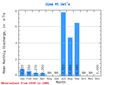
| Statistic | Jan | Feb | Mar | Apr | May | Jun | Jul | Aug | Sep | Oct | Nov | Dec | Annual |
|---|---|---|---|---|---|---|---|---|---|---|---|---|---|
| Mean | 0.82 | 0.55 | 0.37 | 0.35 | 7.73 | 4.65 | 6.44 | 0.00 | |||||
| Standard Deviation | 5.32 | 2.47 | 4.95 | 0.00 | |||||||||
| Min | 0.82 | 0.55 | 0.37 | 0.35 | 1.82 | 1.08 | 2.81 | 0.00 | |||||
| Max | 0.82 | 0.55 | 0.37 | 0.35 | 16.90 | 8.45 | 15.90 | 0.00 | |||||
| Coefficient of Variation | 0.69 | 0.53 | 0.77 |
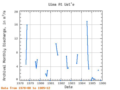
| Year | Jan | Feb | Mar | Apr | May | Jun | Jul | Aug | Sep | Oct | Nov | Dec | Annual | 1978 | 4.55 | 15.90 | 0.00 | 1979 | 5.35 | 3.37 | 5.88 | 0.00 | 1980 | 1.82 | 1.08 | 2.81 | 0.00 | 1981 | 10.50 | 8.45 | 7.30 | 0.00 | 1982 | 6.95 | 3.43 | 3.52 | 0.00 | 1983 | 4.84 | 7.37 | 0.00 | 1984 | 16.90 | 6.08 | 3.23 | 0.00 | 1985 | 0.82 | 0.55 | 0.37 | 0.35 | 2.90 | 0.00 |
|---|
 Return to R-Arctic Net Home Page