|
|
|||||||||||||||||
| Point ID: 9026 | Downloads | Plots | Site Data | Code: 71230 |
|
|
|||||||||||||||||
| Download | |
|---|---|
| Site Descriptor Information | Site Time Series Data |
| Link to all available data | |
|
|
| View: | Statistics | Time Series |
| Units: | mm |
| Statistic | Jan | Feb | Mar | Apr | May | Jun | Jul | Aug | Sep | Oct | Nov | Dec | Annual |
|---|---|---|---|---|---|---|---|---|---|---|---|---|---|
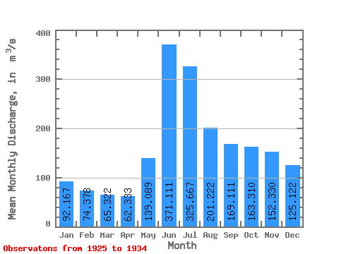
| Mean | 92.17 | 74.38 | 65.32 | 62.33 | 139.09 | 371.11 | 325.67 | 201.22 | 169.11 | 163.31 | 152.33 | 125.12 | 164.27 |
| Standard Deviation | 25.84 | 14.07 | 9.30 | 11.09 | 50.86 | 61.54 | 85.92 | 62.83 | 66.28 | 77.96 | 53.53 | 35.83 | 36.99 |
| Min | 69.90 | 58.90 | 51.50 | 46.50 | 74.80 | 297.00 | 237.00 | 128.00 | 104.00 | 92.10 | 86.30 | 75.50 | 132.98 |
| Max | 138.00 | 100.00 | 79.70 | 79.80 | 235.00 | 464.00 | 520.00 | 329.00 | 298.00 | 359.00 | 261.00 | 177.00 | 241.06 |
| Coefficient of Variation | 0.28 | 0.19 | 0.14 | 0.18 | 0.37 | 0.17 | 0.26 | 0.31 | 0.39 | 0.48 | 0.35 | 0.29 | 0.23 |
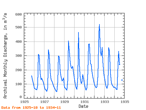
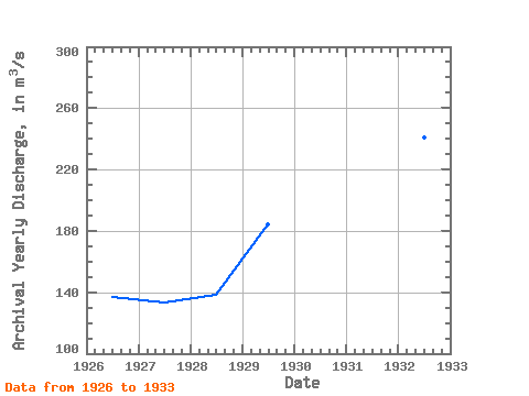
| Year | Jan | Feb | Mar | Apr | May | Jun | Jul | Aug | Sep | Oct | Nov | Dec | Annual | 1925 | 158.00 | 125.00 | 103.00 | 1926 | 69.90 | 64.70 | 63.30 | 59.00 | 92.40 | 309.00 | 301.00 | 176.00 | 131.00 | 141.00 | 125.00 | 109.00 | 136.78 | 1927 | 78.50 | 58.90 | 58.80 | 49.20 | 74.80 | 340.00 | 302.00 | 184.00 | 131.00 | 124.00 | 107.00 | 87.60 | 132.98 | 1928 | 71.00 | 61.50 | 51.50 | 46.50 | 119.00 | 297.00 | 289.00 | 186.00 | 149.00 | 122.00 | 125.00 | 142.00 | 138.29 | 1929 | 74.70 | 71.50 | 64.40 | 56.60 | 133.00 | 404.00 | 332.00 | 248.00 | 217.00 | 210.00 | 224.00 | 177.00 | 184.35 | 1930 | 132.00 | 92.20 | 74.10 | 63.60 | 156.00 | 464.00 | 237.00 | 136.00 | 104.00 | 107.00 | 166.00 | 134.00 | 155.49 | 1931 | 94.30 | 67.50 | 56.80 | 74.50 | 187.00 | 379.00 | 382.00 | 244.00 | 237.00 | 193.00 | 152.00 | 122.00 | 182.43 | 1932 | 93.50 | 81.30 | 75.10 | 79.80 | 158.00 | 462.00 | 520.00 | 329.00 | 298.00 | 359.00 | 261.00 | 176.00 | 241.06 | 1933 | 138.00 | 100.00 | 79.70 | 70.20 | 96.60 | 355.00 | 330.00 | 180.00 | 110.00 | 92.10 | 86.30 | 75.50 | 142.78 | 1934 | 77.60 | 71.80 | 64.20 | 61.60 | 235.00 | 330.00 | 238.00 | 128.00 | 145.00 | 127.00 | 152.00 |
|---|
 Return to R-Arctic Net Home Page