|
|
|||||||||||||||||
| Point ID: 9026 | Downloads | Plots | Site Data | Code: 71230 |
|
|
|||||||||||||||||
| Download | |
|---|---|
| Site Descriptor Information | Site Time Series Data |
| Link to all available data | |
| View: | Time Series | All |
| Units: | mm |
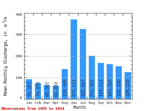
| Statistic | Jan | Feb | Mar | Apr | May | Jun | Jul | Aug | Sep | Oct | Nov | Dec | Annual |
|---|---|---|---|---|---|---|---|---|---|---|---|---|---|
| Mean | 92.17 | 74.38 | 65.32 | 62.33 | 139.09 | 371.11 | 325.67 | 201.22 | 169.11 | 163.31 | 152.33 | 125.12 | 164.27 |
| Standard Deviation | 25.84 | 14.07 | 9.30 | 11.09 | 50.86 | 61.54 | 85.92 | 62.83 | 66.28 | 77.96 | 53.53 | 35.83 | 36.99 |
| Min | 69.90 | 58.90 | 51.50 | 46.50 | 74.80 | 297.00 | 237.00 | 128.00 | 104.00 | 92.10 | 86.30 | 75.50 | 132.98 |
| Max | 138.00 | 100.00 | 79.70 | 79.80 | 235.00 | 464.00 | 520.00 | 329.00 | 298.00 | 359.00 | 261.00 | 177.00 | 241.06 |
| Coefficient of Variation | 0.28 | 0.19 | 0.14 | 0.18 | 0.37 | 0.17 | 0.26 | 0.31 | 0.39 | 0.48 | 0.35 | 0.29 | 0.23 |
 Return to R-Arctic Net Home Page