|
|
|||||||||||||||||
| Point ID: 8991 | Downloads | Plots | Site Data | Code: 71137 |
|
|
|||||||||||||||||
| Download | |
|---|---|
| Site Descriptor Information | Site Time Series Data |
| Link to all available data | |
|
|
| View: | Statistics | Time Series |
| Units: | mm |
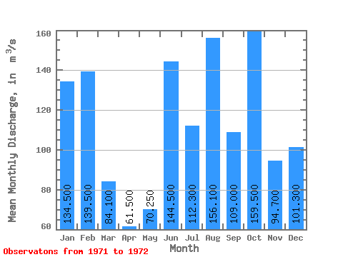
| Statistic | Jan | Feb | Mar | Apr | May | Jun | Jul | Aug | Sep | Oct | Nov | Dec | Annual |
|---|---|---|---|---|---|---|---|---|---|---|---|---|---|
| Mean | 134.50 | 139.50 | 84.10 | 61.50 | 70.25 | 144.50 | 112.30 | 156.10 | 109.00 | 159.50 | 94.70 | 101.30 | 113.94 |
| Standard Deviation | 28.99 | 30.41 | 25.31 | 42.28 | 35.85 | 58.69 | 61.80 | 101.68 | 65.05 | 3.54 | 69.72 | 80.19 | 40.39 |
| Min | 114.00 | 118.00 | 66.20 | 31.60 | 44.90 | 103.00 | 68.60 | 84.20 | 63.00 | 157.00 | 45.40 | 44.60 | 85.38 |
| Max | 155.00 | 161.00 | 102.00 | 91.40 | 95.60 | 186.00 | 156.00 | 228.00 | 155.00 | 162.00 | 144.00 | 158.00 | 142.50 |
| Coefficient of Variation | 0.22 | 0.22 | 0.30 | 0.69 | 0.51 | 0.41 | 0.55 | 0.65 | 0.60 | 0.02 | 0.74 | 0.79 | 0.35 |
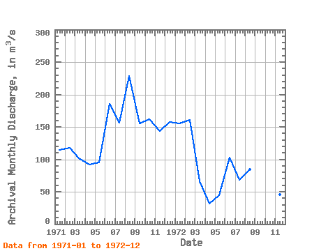
| Year | Jan | Feb | Mar | Apr | May | Jun | Jul | Aug | Sep | Oct | Nov | Dec | Annual | 1971 | 114.00 | 118.00 | 102.00 | 91.40 | 95.60 | 186.00 | 156.00 | 228.00 | 155.00 | 162.00 | 144.00 | 158.00 | 142.50 | 1972 | 155.00 | 161.00 | 66.20 | 31.60 | 44.90 | 103.00 | 68.60 | 84.20 | 63.00 | 157.00 | 45.40 | 44.60 | 85.38 |
|---|
 Return to R-Arctic Net Home Page