|
|
|||||||||||||||||
| Point ID: 8991 | Downloads | Plots | Site Data | Code: 71137 |
|
|
|||||||||||||||||
| Download | |
|---|---|
| Site Descriptor Information | Site Time Series Data |
| Link to all available data | |
|
|
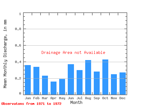
| View: | Statistics | Time Series |
| Units: | m3/s |
| Statistic | Jan | Feb | Mar | Apr | May | Jun | Jul | Aug | Sep | Oct | Nov | Dec | Annual |
|---|---|---|---|---|---|---|---|---|---|---|---|---|---|
| Mean | |||||||||||||
| Standard Deviation | |||||||||||||
| Min | |||||||||||||
| Max | |||||||||||||
| Coefficient of Variation | 0.22 | 0.22 | 0.30 | 0.69 | 0.51 | 0.41 | 0.55 | 0.65 | 0.60 | 0.02 | 0.74 | 0.79 | 0.35 |
| Year | Jan | Feb | Mar | Apr | May | Jun | Jul | Aug | Sep | Oct | Nov | Dec | Annual | 1971 | 1972 |
|---|
 Return to R-Arctic Net Home Page