|
|
|||||||||||||||||
| Point ID: 8943 | Downloads | Plots | Site Data | Code: 71009 |
|
|
|||||||||||||||||
| Download | |
|---|---|
| Site Descriptor Information | Site Time Series Data |
| Link to all available data | |
| View: | Time Series | All |
| Units: | m3/s |
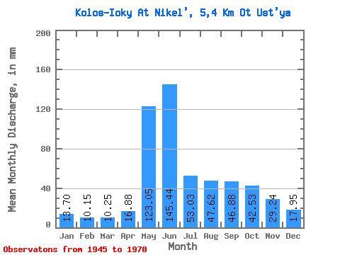
| Statistic | Jan | Feb | Mar | Apr | May | Jun | Jul | Aug | Sep | Oct | Nov | Dec | Annual |
|---|---|---|---|---|---|---|---|---|---|---|---|---|---|
| Mean | 13.70 | 10.25 | 10.24 | 16.88 | 123.02 | 145.45 | 53.02 | 47.61 | 46.88 | 42.51 | 29.23 | 17.95 | 559.00 |
| Standard Deviation | 4.54 | 3.39 | 3.11 | 11.99 | 60.60 | 69.45 | 26.50 | 26.60 | 22.58 | 13.87 | 14.64 | 5.65 | 92.20 |
| Min | 8.21 | 5.16 | 4.53 | 7.40 | 24.63 | 40.00 | 16.98 | 22.08 | 28.50 | 23.50 | 13.70 | 8.49 | 362.55 |
| Max | 23.21 | 17.80 | 16.42 | 54.80 | 279.69 | 315.10 | 115.22 | 122.86 | 115.90 | 73.04 | 78.36 | 28.59 | 758.98 |
| Coefficient of Variation | 0.33 | 0.33 | 0.30 | 0.71 | 0.49 | 0.48 | 0.50 | 0.56 | 0.48 | 0.33 | 0.50 | 0.32 | 0.17 |
 Return to R-Arctic Net Home Page