|
|
|||||||||||||||||
| Point ID: 8943 | Downloads | Plots | Site Data | Code: 71009 |
|
|
|||||||||||||||||
| Download | |
|---|---|
| Site Descriptor Information | Site Time Series Data |
| Link to all available data | |
| View: | Time Series | All |
| Units: | mm |
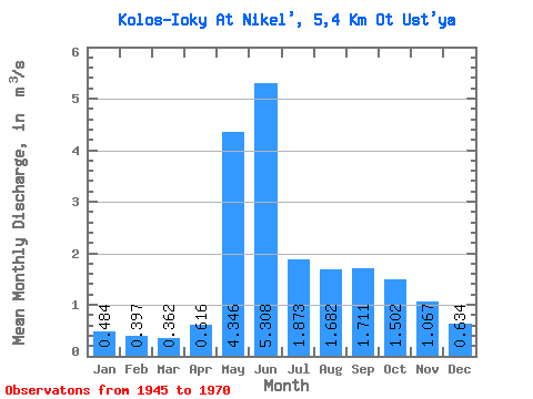
| Statistic | Jan | Feb | Mar | Apr | May | Jun | Jul | Aug | Sep | Oct | Nov | Dec | Annual |
|---|---|---|---|---|---|---|---|---|---|---|---|---|---|
| Mean | 0.48 | 0.40 | 0.36 | 0.62 | 4.35 | 5.31 | 1.87 | 1.68 | 1.71 | 1.50 | 1.07 | 0.63 | 1.68 |
| Standard Deviation | 0.16 | 0.13 | 0.11 | 0.44 | 2.14 | 2.54 | 0.94 | 0.94 | 0.82 | 0.49 | 0.53 | 0.20 | 0.28 |
| Min | 0.29 | 0.20 | 0.16 | 0.27 | 0.87 | 1.46 | 0.60 | 0.78 | 1.04 | 0.83 | 0.50 | 0.30 | 1.09 |
| Max | 0.82 | 0.69 | 0.58 | 2.00 | 9.88 | 11.50 | 4.07 | 4.34 | 4.23 | 2.58 | 2.86 | 1.01 | 2.27 |
| Coefficient of Variation | 0.33 | 0.33 | 0.30 | 0.71 | 0.49 | 0.48 | 0.50 | 0.56 | 0.48 | 0.33 | 0.50 | 0.32 | 0.17 |
 Return to R-Arctic Net Home Page