|
|
|||||||||||||||||
| Point ID: 8931 | Downloads | Plots | Site Data | Code: 70600 |
|
|
|||||||||||||||||
| Download | |
|---|---|
| Site Descriptor Information | Site Time Series Data |
| Link to all available data | |
|
|
| View: | Statistics | Time Series |
| Units: | mm |
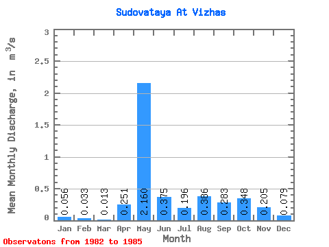
| Statistic | Jan | Feb | Mar | Apr | May | Jun | Jul | Aug | Sep | Oct | Nov | Dec | Annual |
|---|---|---|---|---|---|---|---|---|---|---|---|---|---|
| Mean | 0.06 | 0.03 | 0.01 | 0.25 | 2.16 | 0.38 | 0.20 | 0.39 | 0.28 | 0.35 | 0.20 | 0.08 | 0.42 |
| Standard Deviation | 0.01 | 0.00 | 0.01 | 0.41 | 0.91 | 0.08 | 0.11 | 0.36 | 0.11 | 0.21 | 0.11 | 0.04 | 0.02 |
| Min | 0.05 | 0.03 | 0.00 | 0.00 | 1.52 | 0.28 | 0.08 | 0.05 | 0.14 | 0.18 | 0.10 | 0.04 | 0.41 |
| Max | 0.06 | 0.03 | 0.03 | 0.73 | 2.80 | 0.45 | 0.32 | 0.75 | 0.38 | 0.64 | 0.32 | 0.12 | 0.44 |
| Coefficient of Variation | 0.09 | 0.02 | 0.94 | 1.66 | 0.42 | 0.21 | 0.58 | 0.93 | 0.39 | 0.61 | 0.54 | 0.53 | 0.05 |
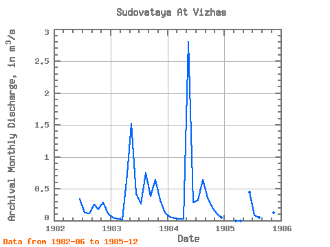
| Year | Jan | Feb | Mar | Apr | May | Jun | Jul | Aug | Sep | Oct | Nov | Dec | Annual | 1982 | 0.34 | 0.12 | 0.11 | 0.25 | 0.18 | 0.28 | 0.11 | 1983 | 0.05 | 0.03 | 0.01 | 0.73 | 1.52 | 0.43 | 0.26 | 0.75 | 0.38 | 0.64 | 0.32 | 0.12 | 0.44 | 1984 | 0.06 | 0.03 | 0.03 | 0.02 | 2.80 | 0.28 | 0.32 | 0.64 | 0.36 | 0.20 | 0.10 | 0.05 | 0.41 | 1985 | 0.00 | 0.00 | 0.45 | 0.08 | 0.05 | 0.14 | 0.37 | 0.12 | 0.04 |
|---|
 Return to R-Arctic Net Home Page