|
|
|||||||||||||||||
| Point ID: 8931 | Downloads | Plots | Site Data | Code: 70600 |
|
|
|||||||||||||||||
| Download | |
|---|---|
| Site Descriptor Information | Site Time Series Data |
| Link to all available data | |
|
|
| View: | Statistics | Time Series |
| Units: | m3/s |
| Statistic | Jan | Feb | Mar | Apr | May | Jun | Jul | Aug | Sep | Oct | Nov | Dec | Annual |
|---|---|---|---|---|---|---|---|---|---|---|---|---|---|
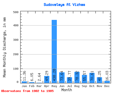
| Mean | 11.46 | 6.01 | 2.71 | 49.22 | 438.22 | 73.64 | 39.66 | 78.41 | 55.47 | 70.50 | 40.26 | 16.08 | 1010.06 |
| Standard Deviation | 1.00 | 0.13 | 2.55 | 81.54 | 183.62 | 15.59 | 22.91 | 73.03 | 21.77 | 43.18 | 21.84 | 8.46 | 50.86 |
| Min | 10.75 | 5.92 | 0.00 | 0.00 | 308.38 | 54.98 | 16.64 | 9.33 | 27.49 | 36.52 | 19.64 | 7.71 | 974.10 |
| Max | 12.17 | 6.10 | 5.07 | 143.34 | 568.06 | 88.36 | 64.92 | 152.16 | 74.62 | 129.84 | 62.84 | 24.34 | 1046.02 |
| Coefficient of Variation | 0.09 | 0.02 | 0.94 | 1.66 | 0.42 | 0.21 | 0.58 | 0.93 | 0.39 | 0.61 | 0.54 | 0.53 | 0.05 |
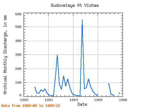
| Year | Jan | Feb | Mar | Apr | May | Jun | Jul | Aug | Sep | Oct | Nov | Dec | Annual | 1982 | 66.76 | 24.34 | 22.32 | 49.09 | 36.52 | 54.98 | 22.32 | 1983 | 10.75 | 5.92 | 3.04 | 143.34 | 308.38 | 84.44 | 52.75 | 152.16 | 74.62 | 129.84 | 62.84 | 24.34 | 1046.02 | 1984 | 12.17 | 6.10 | 5.07 | 4.32 | 568.06 | 54.98 | 64.92 | 129.84 | 70.69 | 40.58 | 19.64 | 9.94 | 974.10 | 1985 | 0.00 | 0.00 | 88.36 | 16.64 | 9.33 | 27.49 | 75.06 | 23.56 | 7.71 |
|---|
 Return to R-Arctic Net Home Page